IMAGES TAKEN NEAR TO
Brief Street, LONDON, SE5 9RD
Introduction
This page details the photographs taken nearby to Brief Street, SE5 9RD by members of the Geograph project.
The Geograph project started in 2005 with the aim of publishing, organising and preserving representative images for every square kilometre of Great Britain, Ireland and the Isle of Man.

There are currently over 7.5m images from over14,400 individuals and you can help contribute to the project by visiting https://www.geograph.org.uk
Image Map
Images are licensed for reuse under creativecommons.org/licenses/by-sa/2.0
Notes
- Clicking on the map will re-center to the selected point.
- The higher the marker number, the further away the image location is from the centre of the postcode.
Image Listing (99 Images Found)
Images are licensed for reuse under creativecommons.org/licenses/by-sa/2.0
Image
Details
Distance
1
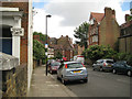
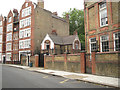
Brief Street
This appropriately-named street has properties ranging from modest two-storey houses on the west side to the five-storey mansion block of flats on the right. The view north is from the corner of Burton Road.
Image: © Robin Stott
Taken: 23 Jun 2013
0.00 miles
2
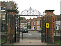
Cormont Road gates, Myatt's Fields Park
The view through the gates is of Brief Street.
Image: © Robin Stott
Taken: 23 Jun 2013
0.02 miles
3
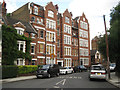
Dover House, Cormont Road
Five-storey flats overlooking Myatt's Fields Park.
Image: © Robin Stott
Taken: 23 Jun 2013
0.03 miles
4
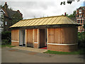
Lottery-funded toilets and baby-change, Myatt's Fields Park
The photo was taken mid-morning; it's the colouring of the building's materials that give that 'caught by the sun's last rays' look. Lottery funding has transformed public parks up and down the UK, after decades of under-investment by local authorities in what is still a non-statutory service.
Image: © Robin Stott
Taken: 23 Jun 2013
0.03 miles
5
School-keeper's house, Cormont Road
The School-keeper's house is sandwiched between the Charles Edward Brooke school, right, and the Dover House flats, left. See Image
Image: © Robin Stott
Taken: 23 Jun 2013
0.04 miles
6
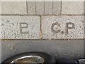
Old Boundary Marker by Burton Road, Camberwell parish
Parish Boundary Marker by the UC road, in parish of Camberwell and Dulwich (Southwark District), Burton Road SW9, in front of No 111 near junction with Brief Street on kerb.
Inscription on left reads:-
LP (combined)
(Lambeth Parish)
Inscription on right reads:-
C.P
(Camberwell Parish)
Surveyed
Milestone Society National ID: SY_LAMB08pb
Milestone Society National ID: SY_SGC19pb
Image: © Milestone Society
Taken: Unknown
0.04 miles
7
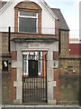
Gate to School-keeper's house, Cormont Road
This modest 2-storey house is dwarfed by Dover House flats to the left and Charles Edward Brooke School to the right Image
Image: © Robin Stott
Taken: 23 Jun 2013
0.04 miles
8
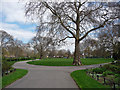
Myatt's Fields Park
A large plane tree at the west entrance. The land was given to the public by the Minet family in 1889 and the park retains a number of Victorian features.
Image: © Stephen Richards
Taken: 27 Apr 2013
0.04 miles
9
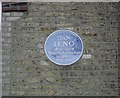
Dan Leno's Blue Plaque on 56 Ackerman Road
Close-up of the plaque on Image
See http://en.wikipedia.org/wiki/Dan_Leno for more details about the Victorian English music hall comedian, whose 1880s act typically revolved around Cockney humour.
Image: © David Anstiss
Taken: 2 Oct 2011
0.04 miles
10
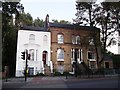
House on Akerman Road
This pair of houses is on the junction of Mostyn Road and Akerman Road.
On the yellow stock brick house (No 56) is a blue plaque.
See Image
Image: © David Anstiss
Taken: 2 Oct 2011
0.05 miles