IMAGES TAKEN NEAR TO
Grange Road, LONDON, SE25 6TG
Introduction
This page details the photographs taken nearby to Grange Road, SE25 6TG by members of the Geograph project.
The Geograph project started in 2005 with the aim of publishing, organising and preserving representative images for every square kilometre of Great Britain, Ireland and the Isle of Man.

There are currently over 7.5m images from over14,400 individuals and you can help contribute to the project by visiting https://www.geograph.org.uk
Image Map
Images are licensed for reuse under creativecommons.org/licenses/by-sa/2.0
Notes
- Clicking on the map will re-center to the selected point.
- The higher the marker number, the further away the image location is from the centre of the postcode.
Image Listing (73 Images Found)
Images are licensed for reuse under creativecommons.org/licenses/by-sa/2.0
Image
Details
Distance
1
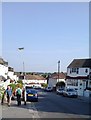
Hythe Road, Thornton Heath
On the nearby lamp-post, the sign marking the entrance to Hythe Path. In the distance, the top of the Norwood Heights, curving around to the west.
Image: © Christopher Hilton
Taken: 18 Jul 2013
0.05 miles
2
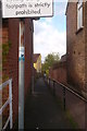
Hythe Path, Thornton Heath
A narrow path linking Hythe Road to Buller Road. At this point on the climb from Thornton Heath up to the Norwood Heights, roads often contour along the slope at different levels, and public footpaths like this provide the only way to cut across the grain of the street pattern and drop downwards more directly.
Image: © Christopher Hilton
Taken: 9 May 2013
0.06 miles
3
Path into Grangewood Park, South Norwood
Grangewood was originally part of the Manor of Whitehorse and the wood known as Whitehorse Wood was part of the Great North Wood. In 1800 the wood was completely surrounded by fields but by the mid 19th century the east and west sides of Whitehorse Wood were cleared for development, whilst the remaining 30 acres to the east of Grange Road were developed as a private estate. This now forms Grangewood Park. It had a mansion at the centre with extensive gardens to the south. Croydon Corporation bought Grangewood Park in 1900. The mansion and grounds were badly damaged in the Second World War and the house was demolished in 1960. The formal garden at the centre of the park marks the site. When the Council acquired the park they built a bandstand but this was also demolished after the Second World War. On the day I was walking into the park, a nearby bonfire was adding its smoke to the autumn sunlight streaming through the trees.
Image: © Marathon
Taken: 21 Oct 2011
0.07 miles
4
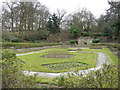
Rose Garden
Rose Garden in Grangewood Park.
Image: © Peter Trimming
Taken: 28 Feb 2009
0.07 miles
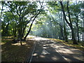
5
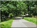
Road in Grangewood Park
Leading out through the park gates round the bend.
Image: © Robin Webster
Taken: 1 Jul 2011
0.07 miles
6
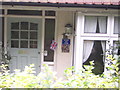
Self-insulting house, Thornton Heath
French-speakers look away now: multi-lingual rudery on Grange Road.
Image: © Christopher Hilton
Taken: 26 Sep 2011
0.07 miles
7
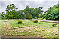
Grangewood Park
Partly wooded open space alongside Grange Road, a former private estate with a 19th Century mansion. The estate was bought by Croydon Corporation in 1900, who then developed a number of recreational facilities on part of the site. The mansion was demolished in 1960 having fallen into disrepair. This is the site of the mansion with the layout of the walls retained.
Image: © Ian Capper
Taken: 6 Jul 2024
0.08 miles
8
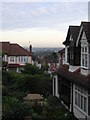
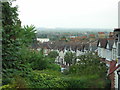
Looking down Annsworthy Crescent to Lenham Road
Image: © Christopher Hilton
Taken: 21 Oct 2011
0.08 miles
9
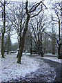
Grangewood Park, after a scattering of snow
Image: © Christopher Hilton
Taken: 14 Jan 2013
0.08 miles
10
Looking down Annsworthy Crescent to Lenham Road
Image: © Christopher Hilton
Taken: 20 Sep 2011
0.08 miles