IMAGES TAKEN NEAR TO
Waldram Park Road, LONDON, SE23 2PP
Introduction
This page details the photographs taken nearby to Waldram Park Road, SE23 2PP by members of the Geograph project.
The Geograph project started in 2005 with the aim of publishing, organising and preserving representative images for every square kilometre of Great Britain, Ireland and the Isle of Man.

There are currently over 7.5m images from over14,400 individuals and you can help contribute to the project by visiting https://www.geograph.org.uk
Image Map
Images are licensed for reuse under creativecommons.org/licenses/by-sa/2.0
Notes
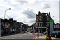
- Clicking on the map will re-center to the selected point.
- The higher the marker number, the further away the image location is from the centre of the postcode.
Image Listing (143 Images Found)
Images are licensed for reuse under creativecommons.org/licenses/by-sa/2.0
Image
Details
Distance
1
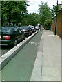
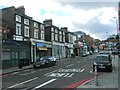
Cycle lane, Stanstead Road, Forest Hill
Image: © Alex McGregor
Taken: 12 Jul 2012
0.04 miles
2
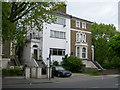
How Could Anyone Do This to an Elegant Old House?
The house on the left would once have been a mirror image of the one on the right. I am amazed that the council ever allowed it to be converted so unsympathetically. This picture was taken on Waldram Park Road, near Montrose Way.
Image: © Danny P Robinson
Taken: 12 May 2007
0.05 miles
3
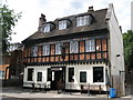
The Forest Hill Hotel, Stanstead Road, SE23
Image: © Mike Quinn
Taken: 4 Jul 2008
0.05 miles
4
Forest Hill: The end of Stanstead Road
Stanstead Road is a long road joining Forest Hill to Catford. Most of the eastern end of it is utilised by the South Circular (A205), but at the extreme western end it is unclassified.
Image: © Dr Neil Clifton
Taken: 23 Aug 2012
0.05 miles
6
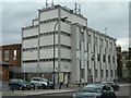
Forest Hill Telephone Exchange
On Waldram Park Road, SE23.
Image: © Danny P Robinson
Taken: 12 May 2007
0.06 miles
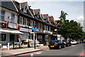
8
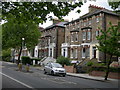
Houses on Waldram Park Road
These fine old houses will by now have been converted into flats. This is the A205 South Circular, a busy through route. On street parking is out of the question.
Image: © Danny P Robinson
Taken: 12 May 2007
0.08 miles
9
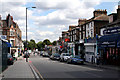
Approaching Forest Hill Station
Road names are not well defined here, but the South Circular (A205) goes off to the right on its sclerotic westward trek, while the pedestrian route to the station goes straight on.
Image: © Dr Neil Clifton
Taken: 23 Aug 2012
0.08 miles
10
Forest Hill: view east from the station
I am not certain about road names here, but it seems the nearer part is part of Perry Vale, but further away (where it becomes also the South Circular Road), its local name is Waldram Park Road.
Image: © Dr Neil Clifton
Taken: 23 Aug 2012
0.09 miles