IMAGES TAKEN NEAR TO
Overhill Road, LONDON, SE22 0PN
Introduction
This page details the photographs taken nearby to Overhill Road, SE22 0PN by members of the Geograph project.
The Geograph project started in 2005 with the aim of publishing, organising and preserving representative images for every square kilometre of Great Britain, Ireland and the Isle of Man.

There are currently over 7.5m images from over14,400 individuals and you can help contribute to the project by visiting https://www.geograph.org.uk
Image Map
Images are licensed for reuse under creativecommons.org/licenses/by-sa/2.0
Notes
- Clicking on the map will re-center to the selected point.
- The higher the marker number, the further away the image location is from the centre of the postcode.
Image Listing (60 Images Found)
Images are licensed for reuse under creativecommons.org/licenses/by-sa/2.0
Image
Details
Distance
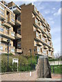
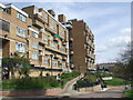
1
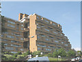
Dawson Heights, Dulwich
The title is the name of the medium-rise housing estate on the hill above Dulwich. The block in this photo, on the road called Overhill, is Bredinghurst.
Image: © Stephen Craven
Taken: 8 Jun 2008
0.02 miles
2
Dawson's Heights
Like a pair of car ferries stranded on top of the hill, these flats are a landmark for the area. Designed by Kate Macintosh, they were built between 1964 and 1972 and have become sought after for their views across London and the local area.
Image: © Brian Whittle
Taken: 25 Mar 2020
0.02 miles
3
Dawson's Hill, East Dulwich
Dawson's Hill, with one of the twin blocks of Dawson Heights perched at the top.
Image: © Malc McDonald
Taken: 27 Jun 2010
0.03 miles
4
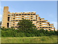
Dawson Heights, SE22
The twin blocks at Dawson Heights were built in 1972, and form a dramatic on the local skyline.
Image: © Malc McDonald
Taken: 27 Jun 2010
0.03 miles
5
Steps at Dawson Heights
A flight of steps leading up to "Bredinghurst", one of the two blocks of flats built at Dawson Heights in 1972.
Image: © Malc McDonald
Taken: 3 Apr 2011
0.03 miles
6
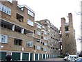
Ladlands, Dawson's Hill
These flats form a twin with Bredinghurst, shown in Image; together they are the Dawson Heights estate. The hill they are on,m Dawson's Hill, has been known as Primrose Hill, Dulwich Hill, and, indeed, Ladlands.
Image: © Derek Harper
Taken: 11 Mar 2011
0.03 miles
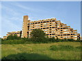
7
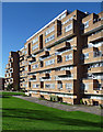
Dawson's Heights, Overhill Road (2)
A landmark building due to its elevated position, its craggy, stepped silhouette appearing as a man-made extension to the hill atop which it stands. Its 300 flats, each with its own balcony, are in two parallel ranges separated by a green space. In contrast to many public housing projects of the time - it was built in 1964-72 - it is clad in brown brick. Designed by Southwark Architect's Department. A listing application in 2012 by the Twentieth Century Society was rejected despite being supported by English Heritage.
Image: © Stephen Richards
Taken: 1 Nov 2014
0.03 miles
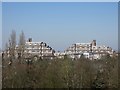
8
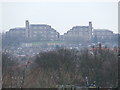
Dawson Heights, SE22
Dawson Heights, taken from Dog Kennel Hill.
Image: © Malc McDonald
Taken: 13 Mar 2010
0.04 miles
9
Dawson Heights, SE22
Two blocks of flats were built at Dawson Heights in 1972. They dominate the skyline, as can be seen in images Image and Image
Image: © Malc McDonald
Taken: 3 Apr 2011
0.04 miles
10
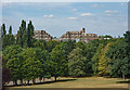
East Dulwich : Dawson's Heights
Built between 1964 and 1972 to design by architect Kate Macintosh of the London Borough of Southwark.
An account of the building of this housing estate may be found at this https://municipaldreams.wordpress.com/2014/11/25/dawsons-heights-east-dulwich-an-example-of-the-almost-lost-art-of-romantic-townscape/. View from Horniman Gardens.
Image: © Jim Osley
Taken: 4 Aug 2018
0.04 miles