IMAGES TAKEN NEAR TO
Dawes Street, LONDON, SE17 2EG
Introduction
This page details the photographs taken nearby to Dawes Street, SE17 2EG by members of the Geograph project.
The Geograph project started in 2005 with the aim of publishing, organising and preserving representative images for every square kilometre of Great Britain, Ireland and the Isle of Man.

There are currently over 7.5m images from over14,400 individuals and you can help contribute to the project by visiting https://www.geograph.org.uk
Image Map
Images are licensed for reuse under creativecommons.org/licenses/by-sa/2.0
Notes
- Clicking on the map will re-center to the selected point.
- The higher the marker number, the further away the image location is from the centre of the postcode.
Image Listing (156 Images Found)
Images are licensed for reuse under creativecommons.org/licenses/by-sa/2.0
Image
Details
Distance
1
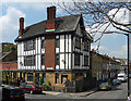
126 Dawes Street
Formerly the Queen Anne pub, Brewers' Tudor inappopriately.
Now flats staring at the Aylesbury Estate.
Image: © Stephen Richards
Taken: 6 May 2013
0.01 miles
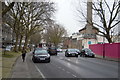
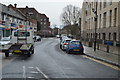
3
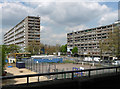
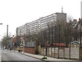
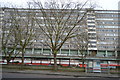
Taplow and Wendover Houses, Thurlow Street
Two of the estate's mammoth 'barrier blocks' as seen from one of its elevated walkways. Built by Southwark Council in 1967-77 by the Borough Architect F.O. Hayes and his successor H.P. Trenton. One of the largest public housing estates in Europe, its 64 acres house around 8,000 people in almost 2,500 dwellings.
It's easy to forget the sub-standard housing it replaced, but the sheer scale of the estate is daunting. Southwark Council has now decided to pull it down - in a strange twist in the early C21st it is carrying out social cleansing on a scale like no other (e.g. see also Image]).
Image: © Stephen Richards
Taken: 6 May 2013
0.05 miles
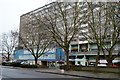
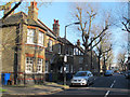
4
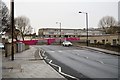
Flint Street, Walworth
Looking south from the junction with Rodney Road. The large building is the Taplow housing block at the centre of the Aylesbury estate, which is scheduled for demolition http://en.wikipedia.org/wiki/Aylesbury_Estate . A very different setting from the village after which it was named http://www.geograph.org.uk/search.php?i=29589300
Image: © Stephen Craven
Taken: 10 Mar 2012
0.06 miles
7
Wooler Street, Walworth (2)
A different style of housing at the east end of the street. Compare Image
Image: © Stephen Craven
Taken: 14 Apr 2015
0.07 miles
9
Villa Street, Walworth: north end
Villa Street runs north-south for about 400 metres through Walworth, and along its length can be seen a variety of housing from the mid-19th to late 20th century. The oldest houses are at the northern end as seen here.
Image: © Stephen Craven
Taken: 14 Apr 2015
0.07 miles