1
The Lord Nelson, Albion Street
Not sure at the time the pub was actually open, but in any case at the time of writing (2016) it does appear to have closed and been turned into an art gallery. Glazed brick ground floor and adverts for Watney Combe Reid (1898), Watney's ales, Reid's stout and Combe's brown ale survive(d). Above the main sign is some corbelling.
Image: © Stephen Richards
Taken: 26 May 2013
0.02 miles
2
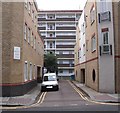
Ainsty Street, Rotherhithe, London, SE16
Off Brunel Road and about 75 yards west of Canon Beck Road and originally called York Street, stretching from the boundary fence of Surrey Docks to about 100 yards north of Brunel Road. At the bottom is the rear of Pine House to the right of which (out of view) can be found Larch House - to the left (again out of view) can be found Beech House. All three form the Ainsty Estate. "Ainsty" is an old name for an area close to the City of York.
Image: © Chris Lordan
Taken: 23 Sep 2009
0.03 miles
3
Battle of the Nile pub (site of). 39, Ainsty Street, Rotherhithe, London, SE16
Image shows Brunel Road and on the left is the junction with Ainsty Street that originally cut across Brunel Road and terminated at Rotherhithe Street. At one of the right hand corners of the junction stood the pub. It was built in 1814 and demolished in the 1930's after having served a time as a cafe. It may be considered too close to the pub in the background (Adam & Eve at No 33) but years ago in Rotherhithe there were many pubs that were closer still.
Image: © Chris Lordan
Taken: 4 Nov 2009
0.03 miles
4
Prince Regent public house (site of)
Site of that was the east side of Clarence Street, Rotherhithe,SE16 (now Canon Beck Road), from 1814 to 1821. After looking at many maps I have taken an 'educated guess' and placed it between Brunel Road (where I am standing to take the image) down to the old Albion Dock as per image.
Image: © Chris Lordan
Taken: 24 Jul 2011
0.03 miles
5
Air shaft, Brunel Road
Above Rotherhithe Tunnel. A plaque records that it was "constructed between 1904 and 1908 by the engineer Sir Maurice Fitzmaurice".
Image: © Stephen Richards
Taken: 26 May 2013
0.03 miles
6
The Lord Nelson, SE16
On the corner of Canon Beck Road & Albion Road.
Not sure what was going to happen to this pub, there were workmen inside the building, but I didn't enquire if it was to remain as a pub or not.
Image: © Phillip Perry
Taken: 21 Sep 2009
0.04 miles
7
Swan Road
A quiet urban street in Rotherhithe - even more than usual on the morning of the London Marathon.
Image: © Martin Addison
Taken: 22 Apr 2012
0.04 miles
8
Ainsty Estate (part), Rotherhithe, London SE16
The estate consists of three blocks: Beech House (shown) in Canon Beck Road, Larch House in Swan Road and Pine House in Albion Street. Built in 1953 over Ainsty Street of which only about 15 yards remains. See image of
Image re definition.
Image: © Chris Lordan
Taken: 12 Oct 2009
0.04 miles
9
Junction of Swan Road with Brunel Road, Rotherhithe
Image: © Ruth Sharville
Taken: 21 Feb 2011
0.04 miles
10
London - Brunel Road
The owners of this house have made quite an effort to decorate their house for the Queens Diamond Jubilee.
Image: © Chris Talbot
Taken: 2 Jun 2012
0.04 miles


