IMAGES TAKEN NEAR TO
Brunel Road, LONDON, SE16 6HZ
Introduction
This page details the photographs taken nearby to Brunel Road, SE16 6HZ by members of the Geograph project.
The Geograph project started in 2005 with the aim of publishing, organising and preserving representative images for every square kilometre of Great Britain, Ireland and the Isle of Man.

There are currently over 7.5m images from over14,400 individuals and you can help contribute to the project by visiting https://www.geograph.org.uk
Image Map
Images are licensed for reuse under creativecommons.org/licenses/by-sa/2.0
Notes
- Clicking on the map will re-center to the selected point.
- The higher the marker number, the further away the image location is from the centre of the postcode.
Image Listing (540 Images Found)
Images are licensed for reuse under creativecommons.org/licenses/by-sa/2.0
Image
Details
Distance
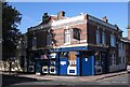
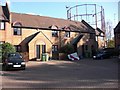
1
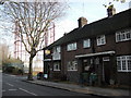
Duke of Edinburgh pub (site of) Dodds Place, Rotherhithe, London, SE16
This stood from 1867 to 1904 on the east corner at the junction with Forsythe Street, which today is in Brunel Road and just west of Kinburn Street i.e. where the two wheelie bins are outside numbers 32 and 34. I assume the pub was demolished as it was about that time that the immediate area changed by extending Brunel Road to the east. I do not know of any 'Edinburgh' connection but half a mile to the east is now an Edinburgh Court.
Image: © Chris Lordan
Taken: 1 Dec 2009
0.01 miles
2
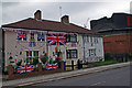
London - Brunel Road
The owners of this house have made quite an effort to decorate their house for the Queens Diamond Jubilee.
Image: © Chris Talbot
Taken: 2 Jun 2012
0.02 miles
3
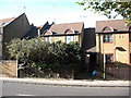
Neston Street (late), Rotherhithe, London SE16
Off Rotherhithe Street between Canon Beck Road and the smaller section of Brunel Road, therefore about where the dwellings shown now stand. Filled in about the early 1960s and originally called Wintershill Street, later changing to Hanover Street but for many years known by the locals as Hanover Bay. This dates back to the mid 1700s, through to the mid 1800s, when foreign seamen made the street world-infamous as a place where "slit throats hung out". See Image for additional information.
Image: © Chris Lordan
Taken: 27 Oct 2009
0.02 miles
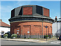
4
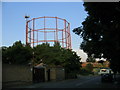
Gasometer, Rotherhithe
An example of adapting old structures to new uses - a disused gasometer now hosts mobile phone masts.
Image: © Stephen Craven
Taken: 4 Jul 2006
0.02 miles
5
Adam and Eve pub, 33, Swan Road, Rotherhithe, London, SE16
Situated at the junction with Brunel Road and first recorded in 1800. In 1907 the Rev Beck wrote in his book about Rotherhithe "Then as befits a waterside parish, we have the names of famous ships eg 'Noahs Ark' : 'Ship Argo' : 'Old Ship York' : 'Swallow Galley' not to mention 'Jolly Sailor' : 'Jolly Caulkers' and the 'Battle of the Nile' and many another, far too many for the needs of the parishioners."
Image: © Chris Lordan
Taken: 12 Oct 2009
0.02 miles
6
Air shaft, Brunel Road
Above Rotherhithe Tunnel. A plaque records that it was "constructed between 1904 and 1908 by the engineer Sir Maurice Fitzmaurice".
Image: © Stephen Richards
Taken: 26 May 2013
0.03 miles
7
Ainsty Street, Rotherhithe, London, SE16
Off Brunel Road and about 75 yards west of Canon Beck Road and originally called York Street, stretching from the boundary fence of Surrey Docks to about 100 yards north of Brunel Road. At the bottom is the rear of Pine House to the right of which (out of view) can be found Larch House - to the left (again out of view) can be found Beech House. All three form the Ainsty Estate. "Ainsty" is an old name for an area close to the City of York.
Image: © Chris Lordan
Taken: 23 Sep 2009
0.03 miles
8
Watermans Arms pub (site of) 55, Swan Lane, Rotherhithe, London, SE16
This was a pub between 1852 and 1907 and thereafter a shop. It abutted Winchelsea House of the Swan Estate shown on the right. I remember it, 1960s, as a two storey building. I cannot answer my own query :- 2 storeys / abutting / window above mural. The pub protruded a little way past the bollard, as in the 1960s the road was very narrow. The shop disappeared in the early 1970s. Building in the centre is Rye House and in the background is the Adams Garden Estate.
Image: © Chris Lordan
Taken: 9 Dec 2009
0.03 miles
9
Blue Coat Boy pub (site of). 8, Dodds Place (late), Rotherhithe, London, SE16
Dodds Place was once at the east end and slightly north of Adam Street (now Brunel Road), between Canon Beck Road and Kinburn Street. The pub would have stood about the centre of the forecourt shown. It was first recorded in 1767 and destroyed by fire in 1827. In 1830 its licence was refused and it became 8 Dodds Place. It was also known as the 'Dial'.
Image: © Chris Lordan
Taken: 4 Nov 2009
0.03 miles
10
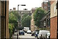
View along Canon Beck Road from the Thames Path
Looking south-southeast.
Image: © Robert Lamb
Taken: 12 Jul 2014
0.03 miles