IMAGES TAKEN NEAR TO
Tawny Way, LONDON, SE16 2NJ
Introduction
This page details the photographs taken nearby to Tawny Way, SE16 2NJ by members of the Geograph project.
The Geograph project started in 2005 with the aim of publishing, organising and preserving representative images for every square kilometre of Great Britain, Ireland and the Isle of Man.

There are currently over 7.5m images from over14,400 individuals and you can help contribute to the project by visiting https://www.geograph.org.uk
Image Map
Images are licensed for reuse under creativecommons.org/licenses/by-sa/2.0
Notes
- Clicking on the map will re-center to the selected point.
- The higher the marker number, the further away the image location is from the centre of the postcode.
Image Listing (218 Images Found)
Images are licensed for reuse under creativecommons.org/licenses/by-sa/2.0
Image
Details
Distance
1
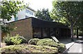
Dockers Shelter - Redriff Road, SE16
It is a replica about 50 yards north of Lower Road; the original was on the opposite side of the road and much closer to Lower Road. It was a place where hundreds of dockers met about 7am each weekday morning hoping to be signed on (bomping on) for a day's work. They would completely block the junction, which at the time had two-way traffic. Why the replica was built where it is anyone's guess; the original site would have been perfect.
Image: © Chris Lordan
Taken: 10 Sep 2009
0.02 miles
2
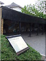
Former dockers' shelter
The former dockers' shelter at Surrey Docks.
Image: © Malc McDonald
Taken: 10 May 2010
0.02 miles
3
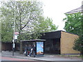
Bus stop and former dockers' shelter
A bus stop in front of the former dockers' shelter at Surrey Docks (now Surrey Quays).
Image: © Malc McDonald
Taken: 10 May 2010
0.03 miles
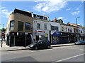
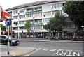
4

The Surrey Docks, Surrey Quays, London
Pub on the junction of Lower Road, Redcriff Road and Tawny Way.
Part of the Wetherspoons Chain.
Image: © David Anstiss
Taken: 18 Aug 2010
0.03 miles
5
Warrior public house (site of)
Site of what was 209 Lower Road, Rotherhithe, SE16 junction with Maynard Road and opposite Cope Street. Opened in 1862 as the 'Manor Beer House' and closed with the building of the Osprey Estate in the early 1970s. Warrior II (now Surrey Docks pub) was built about 50 yards to the left at the junction with Redriff Road. Image shows Tawny Way of the Osprey Estate.
Image: © Chris Lordan
Taken: 17 Aug 2011
0.04 miles
6
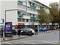
Lower Road, Rotherhithe
Street scene in the Surrey Quays area of Rotherhithe.
Image: © Stephen McKay
Taken: 6 Nov 2015
0.04 miles
7
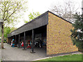
The Dockers Shelter, Redriff Way, Rotherhithe
Now used as a large bus shelter, this was historically the place where dock workers would wait to find casual piece work (what we would now call "zero hours contracts").
Image: © Stephen Craven
Taken: 19 Apr 2014
0.04 miles
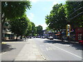
9
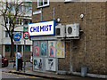
Cope Street, Rotherhithe
Showing the junction with Lower Road in the Surrey Quays area. The use of the traditional 'chemist' for a pharmacy is generally dying out, but evidently not here.
Image: © Stephen McKay
Taken: 6 Nov 2015
0.05 miles