IMAGES TAKEN NEAR TO
Catherine Grove, LONDON, SE10 8BG
Introduction
This page details the photographs taken nearby to Catherine Grove, SE10 8BG by members of the Geograph project.
The Geograph project started in 2005 with the aim of publishing, organising and preserving representative images for every square kilometre of Great Britain, Ireland and the Isle of Man.

There are currently over 7.5m images from over14,400 individuals and you can help contribute to the project by visiting https://www.geograph.org.uk
Image Map
Images are licensed for reuse under creativecommons.org/licenses/by-sa/2.0
Notes
- Clicking on the map will re-center to the selected point.
- The higher the marker number, the further away the image location is from the centre of the postcode.
Image Listing (247 Images Found)
Images are licensed for reuse under creativecommons.org/licenses/by-sa/2.0
Image
Details
Distance
1
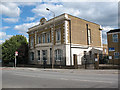
Royal Kent Dispensary, Greenwich High Road
Despite the 1783 date, this building is actually mid-19th century according to the list description (grade 2, List Entry Number 1078995). It was later part of the Miller General Hospital until 1974, then a children's home, and finally converted to housing. Source: page on the Ashburnham Triangle Association website (later removed)
Image: © Stephen Craven
Taken: 21 Jul 2008
0.04 miles
2
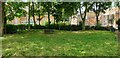
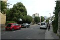
Catherine Grove
View across the small public garden in Catherine Grove: straight ahead is Charter Buildings, the former Blackheath Road Higher Elementary School built in 1904 and now converted into flats, and on the far right is the Hilton Doubletree hotel, formerly Maurice Drummond House a police sector House built in 1946.
The garden, responsibility for whose maintenance is not clear (the Royal Borough of Greenwich do not list it in their directory), is in a poor state and is rarely mowed or otherwise cared for. That said, local residents do tend one of the flower beds and occasionally prune the shrubs.
Layers of London provides a full description of the street https://www.layersoflondon.org/map?l=eyJmcmVlX3RleHRfcXVlcnkiOm51bGwsInNlYXJjaF9wYWdlIjoxLCJjYXRlZ29yeV9hbmRfdGVybV9maWx0ZXJzIjp7InRlcm1faWQiOm51bGwsImNhdGVnb3J5X2lkIjoxfSwiYWN0aXZlX2xheWVyX2dyb3VwX2lkcyI6W119&m=eyJjZW50ZXIiOls1MS41MDc0LDAuMTI3OF0sInpvb20iOjEwLCJsaWdodHNPdXQiOmZhbHNlfQ%3D%3D&record=11760
Image: © Nigel Jones
Taken: 28 Jul 2021
0.05 miles
3
Royal Kent Instituted Dispensary
Grade II listed building, see https://historicengland.org.uk/listing/the-list/list-entry/1078995 and Image
Image: © Hugh Venables
Taken: 31 Oct 2021
0.05 miles
4
Royal Kent Dispensary (2)
For the history of this building see Image
Image: © Stephen Craven
Taken: 29 Aug 2009
0.05 miles
6
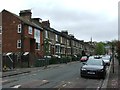
Egerton Drive
Looking along Egerton Drive towards the junction with Ashburnham Grove.
Image: © DS Pugh
Taken: 2 Aug 2022
0.05 miles
7
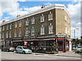
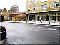
The Golden Chippy
The Golden Chippy / Golden Vineyard / Golden Cafe (presumably all under the same management) on the corner of Devonshire Drive (right) and Greenwich High Road (foreground).
Image: © Stephen Craven
Taken: 29 Aug 2009
0.06 miles
8
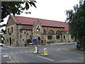
Seventh Day Adventist Church, Devonshire Drive
Built as St Paul's Anglican Church 1866, closed in 1978 and since used by other denominations (Wesleyan, Calvary Church and presently Seventh Day Adventist).
Image: © Stephen Craven
Taken: 26 Jul 2005
0.06 miles
9
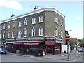
Golden parade
Golden Chippy, Golden Vineyard and Golden Café
Image: © Malc McDonald
Taken: 3 May 2010
0.06 miles