IMAGES TAKEN NEAR TO
Parc Loktudi, FISHGUARD, SA65 9AF
Introduction
This page details the photographs taken nearby to Parc Loktudi, SA65 9AF by members of the Geograph project.
The Geograph project started in 2005 with the aim of publishing, organising and preserving representative images for every square kilometre of Great Britain, Ireland and the Isle of Man.

There are currently over 7.5m images from over14,400 individuals and you can help contribute to the project by visiting https://www.geograph.org.uk
Image Map
Images are licensed for reuse under creativecommons.org/licenses/by-sa/2.0
Notes
- Clicking on the map will re-center to the selected point.
- The higher the marker number, the further away the image location is from the centre of the postcode.
Image Listing (29 Images Found)
Images are licensed for reuse under creativecommons.org/licenses/by-sa/2.0
Image
Details
Distance
1

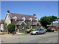
New houses
This development on the southwestern approach into Abergwaun/Fishguard is taking place on land adjoining Maesgwyn farm.
Image: © Natasha Ceridwen de Chroustchoff
Taken: 6 Feb 2007
0.02 miles
2
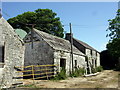
Outbuildings at Maesgwynne
The farmhouse is to the right, out of the picture, but the building at the end, with a chimney, looks as if it was a dwelling once. This was a working farm until recently; much of the land was sold for residential development.
Image: © Natasha Ceridwen de Chroustchoff
Taken: 24 Jun 2010
0.06 miles
3
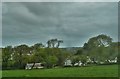
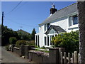
Maes Gwyn Farm
On the outskirts of the town of Fishguard
Image: © Deborah Tilley
Taken: 25 May 2015
0.07 miles
4
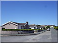
Clos-y-Bigney
Modern residential development on the western edge of Fishguard, on the slope of Bigney Hill.
Image: © Natasha Ceridwen de Chroustchoff
Taken: 24 Jun 2010
0.08 miles
5
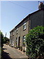
Ropeyard Lane
These houses are no doubt contemporary with the rope making industry in Fishguard but the surrounding area was developed in the second half of the C20 as a residential estate of neat bungalows in quiet culs de sac.
Image: © Natasha Ceridwen de Chroustchoff
Taken: 24 Jun 2010
0.11 miles
6
Foundry House
The name is the only clue that there must once have been a foundry here, in Ropeyard Lane.
Image: © Natasha Ceridwen de Chroustchoff
Taken: 24 Jun 2010
0.11 miles
7
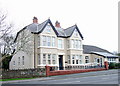
Wintern Day Centre
Large house providing day care of the elderly and a venue for other forms social care,on the southern edge of the town. Run by Pembrokeshire County Council.
Image: © Natasha Ceridwen de Chroustchoff
Taken: 8 Feb 2008
0.11 miles
8
Ropeyard barn conversion
Two cottages have been created from this old barn in the part of the town still called Ropeyard: a remnant of the past in an otherwise modern residential area.
Image: © Natasha Ceridwen de Chroustchoff
Taken: 24 Jun 2010
0.14 miles
9

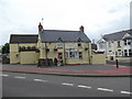
Pendre Inn, Abergwaun/Fishguard
Pendre, 'top of the town' in Welsh, was the site of one of the tollgates that became the focus of the Rebecca Riots in the 1840's. Local people across south and west Wales, dressed as women for disguise, caused mayhem when they protested against extortionate charges for the use of turnpike roads. In September 1843 several hundred rioters tore down the Fishguard tollgate and fired muskets.
Image: © Natasha Ceridwen de Chroustchoff
Taken: 8 Nov 2006
0.14 miles