IMAGES TAKEN NEAR TO
Llechryd, CARDIGAN, SA43 2QB
Introduction
This page details the photographs taken nearby to SA43 2QB by members of the Geograph project.
The Geograph project started in 2005 with the aim of publishing, organising and preserving representative images for every square kilometre of Great Britain, Ireland and the Isle of Man.

There are currently over 7.5m images from over14,400 individuals and you can help contribute to the project by visiting https://www.geograph.org.uk
Image Map
Images are licensed for reuse under creativecommons.org/licenses/by-sa/2.0
Notes
- Clicking on the map will re-center to the selected point.
- The higher the marker number, the further away the image location is from the centre of the postcode.
Image Listing (9 Images Found)
Images are licensed for reuse under creativecommons.org/licenses/by-sa/2.0
Image
Details
Distance
3
Garnon's Mill Road, Cilgerran
The road was built by Benjamin Hammet of Castell Malgwyn, at the end of the C18, to replace the original Llechryd to Cilgerran road which ran through his property, see Image Such were the days when the re-routing of an inconvenient highway, along with the removal of other undesirable features such as peasants' dwellings, could be effected by the rich and powerful without let or hindrance. As put by Oliver Goldsmith in The Deserted Village:
The man of wealth and pride
Takes up a space that many poor supplied;
Space for his lake, his park's extended bounds,
Space for his horses, equipage and hounds.
Image: © Natasha Ceridwen de Chroustchoff
Taken: 19 Jun 2010
0.09 miles
4
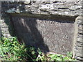
Plaque on Hammet Bridge
HAMMET BRIDGE
was erected and
GARNON'S MILL ROAD
was made at the sole expence of
SIR BENJAMIN HAMMET Knt.
Opened Aug. 21st 1800
Image: © Natasha Ceridwen de Chroustchoff
Taken: 19 Jun 2010
0.09 miles
5
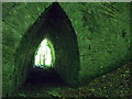
Flood arch under Hammet Bridge
There are a pointed flood arches on both sides of the main span (although the one on the other side is blocked up by earth.) I wonder how often the river is so high that they come into use?
Image: © Natasha Ceridwen de Chroustchoff
Taken: 19 Jun 2010
0.10 miles
6
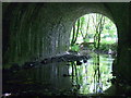
Under Hammet Bridge
The single span of this 200 year old bridge with a low Afon Morgenau flowing beneath it.
The masonry looks in good repair but some tie rods seem to have been inserted into the bridge in recent decades.
Image: © Natasha Ceridwen de Chroustchoff
Taken: 19 Jun 2010
0.10 miles
7
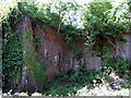
Disused quarry near Cwm Morgenau
Not marked on either the new or old OS maps but this solid rock face could have been the source of stone for Benjamin Hammet's bridge a little way away. However some of the surface is so smoothly cut that perhaps it can only have been done with modern machinery.
Image: © Natasha Ceridwen de Chroustchoff
Taken: 19 Jun 2010
0.12 miles
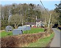
8
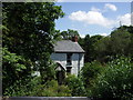
Garnon's Mill
Beside Garnon's Mill Road and no doubt once powered by water from the Morgenau. Presumably it was a corn mill and perhaps part of the Castell Malgwyn estate.
Image: © Natasha Ceridwen de Chroustchoff
Taken: 19 Jun 2010
0.20 miles
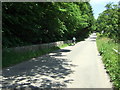
9
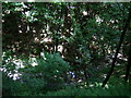
Looking down into Cwm Morgenau
The thickness of the foliage and the dark shadows on a sunny day make it hard to gauge the depth but at some points the rivulet runs as much as 100 feet below the track, passing through a steep sided ravine which is difficult of access today. When the original landscaping took place the idea was to create a romantic dingle that could be followed and crossed in several places. The Morgenau, a mere trickle today after an unusually dry spring, is normally a fast-flowing stream whose noisy babble was intended to contrast the lazy flow of the Teifi on the opposite side of the grounds.
Image: © Natasha Ceridwen de Chroustchoff
Taken: 19 Jun 2010
0.22 miles