IMAGES TAKEN NEAR TO
Jordan Crescent, ROTHERHAM, S61 2NH
Introduction
This page details the photographs taken nearby to Jordan Crescent, S61 2NH by members of the Geograph project.
The Geograph project started in 2005 with the aim of publishing, organising and preserving representative images for every square kilometre of Great Britain, Ireland and the Isle of Man.

There are currently over 7.5m images from over14,400 individuals and you can help contribute to the project by visiting https://www.geograph.org.uk
Image Map
Images are licensed for reuse under creativecommons.org/licenses/by-sa/2.0
Notes
- Clicking on the map will re-center to the selected point.
- The higher the marker number, the further away the image location is from the centre of the postcode.
Image Listing (14 Images Found)
Images are licensed for reuse under creativecommons.org/licenses/by-sa/2.0
Image
Details
Distance
1
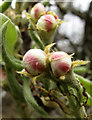
An old variety of apple
I don't know which apple variety of apple this is, but it's an old one. Still quite a small tree and found on north side of the towpath opposite the windpump.
Image: © Nic Franklin-Woolley
Taken: 18 Apr 2010
0.19 miles
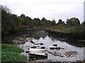
2

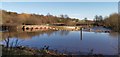
Sluice and lock at Holmes Goit
On Sheffield and Tinsley Canal
Image: © Chris Morgan
Taken: 12 Feb 2020
0.20 miles
3
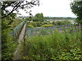
Footbridge with view of sewage works
In Jordan, Rotherham, the railway which is crossed by the bridge goes to Sheffield.
Image: © Peter Barr
Taken: 13 Jul 2011
0.20 miles
4
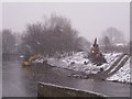
Dredging the Don in the snow at Jordan
Three diggers carry out Environment Agency work to improve the river flow below the weir at Jordan. This is part of a strategy to lessen the chances of the Don flooding Sheffield again. The concrete wall in the river separates the Don (right) from the Blackburn Meadows sewage works outfall (left). The OS 1:50000 map, shown on Geograph calls this area Jordon, but the OS 1:25000 Explorer map and Get-a-map calls it Jordan.
Image: © Martin Speck
Taken: 2 Feb 2009
0.21 miles
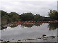
6
Jordan Dam after heavy rains
The protective boom for canal traffic has been swept away and awaits repair
Image: © Chris Morgan
Taken: 12 Feb 2020
0.22 miles
7
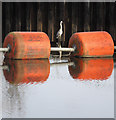
Weir Heron
confluence of canal and River Don
Image: © Nic Franklin-Woolley
Taken: 21 Mar 2010
0.22 miles
8
Jordan Weir, River Don
The shot is towards the barrage across the top of Jordan Weir on the Don. It's pretty hefty because this is a navigable stretch of the Don, ENE of Tinsley. As the river skirts around the back of the big sewage works at Tinsley (anyone driving along Tinsley Viaduct on the M1 will know where I mean), the smell can be pretty ripe as indeed it was when I took this picture. Pity any boaters making the trip because there was a lot of debris.
Image: © David Morris
Taken: 29 Oct 2005
0.22 miles
9
Jordan, River Don
This is the cut that boaters take to Jordan Top Lock if they don't fancy shooting the weir :-)
Image: © David Morris
Taken: 29 Oct 2005
0.22 miles