IMAGES TAKEN NEAR TO
Seanor Lane, CHESTERFIELD, S45 8DH
Introduction
This page details the photographs taken nearby to Seanor Lane, S45 8DH by members of the Geograph project.
The Geograph project started in 2005 with the aim of publishing, organising and preserving representative images for every square kilometre of Great Britain, Ireland and the Isle of Man.

There are currently over 7.5m images from over14,400 individuals and you can help contribute to the project by visiting https://www.geograph.org.uk
Image Map
Images are licensed for reuse under creativecommons.org/licenses/by-sa/2.0
Notes
- Clicking on the map will re-center to the selected point.
- The higher the marker number, the further away the image location is from the centre of the postcode.
Image Listing (47 Images Found)
Images are licensed for reuse under creativecommons.org/licenses/by-sa/2.0
Image
Details
Distance
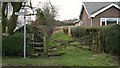
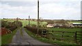
1
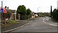
Seanor Lane
The photograph shows the western end of Seanor Lane, a cul-de-sac and unclassified county road, from its junction with Parkhouse Road, Lower Pilsley.
To the left Parkhouse Road continues toward its junction with Church Lane and Little Morton Road in North Wingfield.
To the right Image continues toward Parkhouse Green, Lower Pilsley.
For a photograph of the eastern (ahead) end of the 'metalled' http://en.wikipedia.org/wiki/Paved section of the lane, click here Image
Image: © Alan Walker
Taken: 28 Feb 2007
0.01 miles
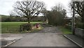
2
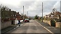
Seanor Lane
The photograph was taken from the eastern end of the 'metalled' http://en.wikipedia.org/wiki/Paved section of the cul-de-sac, Seanor Lane¹ in Lower Pilsley.
Just beyond the first telegraph pole on the right is the start of a Image (not obvious in this photograph) connecting Seanor Lane with Dark Lane¹ in North Wingfield.
For a photograph of the lane taken from the same viewpoint but looking in the opposite (easterly) direction, click here Image
For a photograph of the western (ahead, some 500- to 600metres) end of the lane at its junction with Image¹, click here Image
¹ Road name information from OS Maps at:-
Elgin, http://www.elgin.gov.uk/ and the
Mapping Portal of the Derbyshire Partnership, http://derbyshiremaps.derbyshire.gov.uk/
Image: © Alan Walker
Taken: 28 Feb 2007
0.01 miles
3
Footpath
The photograph shows a footpath leading northward toward Image (ahead, some 60metres) from Parkhouse Road, Lower Pilsley (behind the viewpoint).
For a more northerly (ahead, some 60metres) photograph of this footpath but looking back, toward this viewpoint, click here Image
Image: © Alan Walker
Taken: 6 Mar 2007
0.05 miles
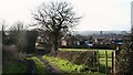
4
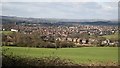
View over fields
This view over fields was taken from Image, Lower Pilsley opposite its junction with Image and is looking in a north-westerly direction toward North Wingfield http://en.wikipedia.org/wiki/North_Wingfield .
The church tower toward the left of the picture is that of Church of St Lawrence
The row of houses in the middle distance (centre, right) are on Seanor Lane, Lower Pilsley.
Image: © Alan Walker
Taken: 26 Feb 2007
0.05 miles
5
Footpath
The photograph shows a footpath leading southward (ahead) to Parkhouse Road, Lower Pilsley from the end of Image
For a more southerly (ahead, some 60metres) photograph of this footpath but looking back, toward this viewpoint, click here Image
Image: © Alan Walker
Taken: 28 Feb 2007
0.06 miles
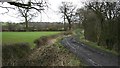
6
Seanor Lane
This is the eastern end of the 'metalled' http://en.wikipedia.org/wiki/Paved section of Seanor Lane, Lower Pilsley and it is at this point that two public footpaths meet the lane.
Ahead Image continues for a further 425metres (approximately) where it meets http://www.multimap.com/map/browse.cgi?lat=53.1703&lon=-1.3734&scale=25000&icon=x with a bridleway to the Five Pits Trail at Timber Lane. This bridleway is also linked to a number of footpaths, including one to Image near Waterloo.
To the left is a Image shared by a footpath to Seanor Farm.
To the right (just by the telegraph pole and not the further entrance) is a Image toward Parkhouse Road.
The red bin is one of many placed by the local district council for the use of considerate dog owners.
For a photograph of the lane taken from the same viewpoint but looking in the opposite (westerly) direction, click here Image
Some 500metres to 600metres behind the viewpoint is Image’s junction with Image
Image: © Alan Walker
Taken: 28 Feb 2007
0.06 miles
7
Seanor Lane
This photograph of Seanor Lane, Lower Pilsley shows the last (approximately) 120metres of the compacted stone and earth section before it joins the metalled section (ahead).
From the post and wire fence (near right) there is this view of Image
For a more westerly (ahead) photograph of Seanor Lane but looking back, toward this viewpoint, click here Image
For a more westerly (ahead) photograph of the metalled section of Seanor Lane, click here Image
Behind the viewpoint Image continues eastward toward its junction with a bridleway that leads on to the Five Pits Lane at Timber Lane.
Image: © Alan Walker
Taken: 6 Mar 2007
0.09 miles
8
Seanor Lane
This section of Seanor Lane is a constructed from compacted stones and earth.
Ahead, where the lane ends, the route continues as a bridleway leading to the Five Pits Trail at Timber Lane. This bridleway is also linked to a number of footpaths, including one to Image near Waterloo.
For a more easterly (ahead) photograph of Seanor Lane but looking back, toward this viewpoint, click here Image
A few metres behind this viewpoint is the eastern end of the 'metalled' http://en.wikipedia.org/wiki/Paved section of Image, Lower Pilsley.
Image: © Alan Walker
Taken: 28 Feb 2007
0.10 miles
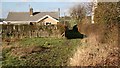
9
Farm track
The photograph shows a track that shares a footpath to Image¹ (the buildings on the right) from Image¹, Lower Pilsley.
See also this photograph by Nikki Mahadevan, Image
¹ Road/Farm name information from OS Maps at:-
Elgin, http://www.elgin.gov.uk/ and the
Mapping Portal of the Derbyshire Partnership, http://derbyshiremaps.derbyshire.gov.uk/
Image: © Alan Walker
Taken: 28 Feb 2007
0.12 miles
10
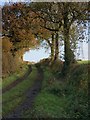
Seanor Lane, Lower Pilsley
The western end of Seanor Lane is metalled but, from Bridle Path Farm onward, the eastern end (part of which is seen here) is constructed of compacted stones and earth.
Image: © Nikki Mahadevan
Taken: 21 Nov 2006
0.12 miles