IMAGES TAKEN NEAR TO
Stifford Clays Road, GRAYS, RM16 3LX
Introduction
This page details the photographs taken nearby to Stifford Clays Road, RM16 3LX by members of the Geograph project.
The Geograph project started in 2005 with the aim of publishing, organising and preserving representative images for every square kilometre of Great Britain, Ireland and the Isle of Man.

There are currently over 7.5m images from over14,400 individuals and you can help contribute to the project by visiting https://www.geograph.org.uk
Image Map
Images are licensed for reuse under creativecommons.org/licenses/by-sa/2.0
Notes
- Clicking on the map will re-center to the selected point.
- The higher the marker number, the further away the image location is from the centre of the postcode.
Image Listing (17 Images Found)
Images are licensed for reuse under creativecommons.org/licenses/by-sa/2.0
Image
Details
Distance
2
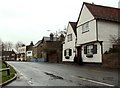
Part of Stifford Clays Road, Orsett
These are just a few of the many interesting old buildings in Orsett village. This picture was taken from the entrance to Whitfields Farm.
Image: © Robert Edwards
Taken: 10 Mar 2008
0.03 miles
3

The King's Arms, Baker Street
As well as the road to the left being called Baker Street, the whole settlement around this crossroads has the same name.
Image: © Robin Webster
Taken: 18 Sep 2011
0.04 miles
4
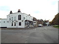
King's Arms, Orsett
The King's Arms pub in Orsett.
The banner on the pub wall, to the left of the image, voices opposition to a proposal to build another bridge nearby across the River Thames.
Image: © Malc McDonald
Taken: 28 Oct 2017
0.05 miles
5
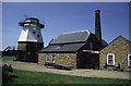
Baker Street Windmill
This is a photograph before the cap and sails were restored. At an earlier stage it had been comprehensively derelict. It is now converted to a dwelling but retains much of the original machinery and is most interesting.
Image: © Chris Allen
Taken: 12 Jun 1994
0.06 miles
6
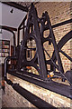
Baker Street Mill - incomplete beam engine
This complex consist of a smock type windmill and an adjoining steam mill that was powered by this beam engine. The site was allowed to become very derelict but was ultimately restored as a private dwelling while retaining the machinery. This visit was with the permission of the then owner but since then it has been advertised for sale and interior pictures have appeared on websites for the sale. There is also a fine picture in Colin Bowden's book - The End of a Revolution.
The beam engine is probably c1840 and was built by Thomas Middleton of Southwark. The slide valve cylinder is 9" x 24" and the flywheel is 8' diameter. The engine has lost its beam, connecting rod, eccentric rod and governor. It is plumbed up to a locomotive type boiler that replaced the original boiler in 1906. Steam milling ceased by about 1910 and the windmill ceased work c1914-15.
Image: © Chris Allen
Taken: 11 Dec 1999
0.06 miles
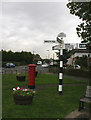
7
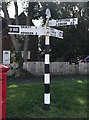
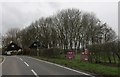
Old Direction Sign - Signpost by the B188, Baker Street crossroads
Half-moon finial - 4 arms; Essex CC parish half-moon (Maldon) by the B188, in parish of Orsett (Thurrock District), Baker Street crossroads.
Surveyed
Milestone Society National ID: EX_TQ6381.
Image: © Milestone Society
Taken: Unknown
0.06 miles
8
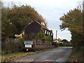
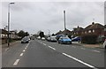
Stifford Clays Road, Orsett
Stifford Clays Road, entering the village of Orsett.
Image: © Malc McDonald
Taken: 28 Oct 2017
0.07 miles
9
Sign Post
This finger post is on the junction of Baker Street and High Road, Orsett, opposite the Kings Arms Pub.
Image: © terry joyce
Taken: 18 Oct 2010
0.08 miles