Baker Street Mill - incomplete beam engine
Introduction
The photograph on this page of Baker Street Mill - incomplete beam engine by Chris Allen as part of the Geograph project.
The Geograph project started in 2005 with the aim of publishing, organising and preserving representative images for every square kilometre of Great Britain, Ireland and the Isle of Man.

There are currently over 7.5m images from over 14,400 individuals and you can help contribute to the project by visiting https://www.geograph.org.uk
Baker Street Mill - incomplete beam engine
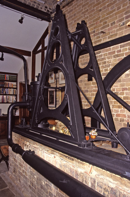
Image: © Chris Allen Taken: 11 Dec 1999
This complex consist of a smock type windmill and an adjoining steam mill that was powered by this beam engine. The site was allowed to become very derelict but was ultimately restored as a private dwelling while retaining the machinery. This visit was with the permission of the then owner but since then it has been advertised for sale and interior pictures have appeared on websites for the sale. There is also a fine picture in Colin Bowden's book - The End of a Revolution. The beam engine is probably c1840 and was built by Thomas Middleton of Southwark. The slide valve cylinder is 9" x 24" and the flywheel is 8' diameter. The engine has lost its beam, connecting rod, eccentric rod and governor. It is plumbed up to a locomotive type boiler that replaced the original boiler in 1906. Steam milling ceased by about 1910 and the windmill ceased work c1914-15.
Images are licensed for reuse under creativecommons.org/licenses/by-sa/2.0
Image Location


Leaflet Map data © OpenStreetMap
Latitude
51.506945
Longitude
0.351783