IMAGES TAKEN NEAR TO
Cliftons Lane, REIGATE, RH2 9RA
Introduction
This page details the photographs taken nearby to Cliftons Lane, RH2 9RA by members of the Geograph project.
The Geograph project started in 2005 with the aim of publishing, organising and preserving representative images for every square kilometre of Great Britain, Ireland and the Isle of Man.

There are currently over 7.5m images from over14,400 individuals and you can help contribute to the project by visiting https://www.geograph.org.uk
Image Map
Images are licensed for reuse under creativecommons.org/licenses/by-sa/2.0
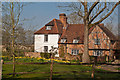
Notes
- Clicking on the map will re-center to the selected point.
- The higher the marker number, the further away the image location is from the centre of the postcode.
Image Listing (43 Images Found)
Images are licensed for reuse under creativecommons.org/licenses/by-sa/2.0
Image
Details
Distance
1
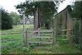
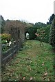
Footpath 24 alongside Harolyn
Footpath Reigate 24 from Buckland Green to Reigate Heath follows the wall (on the right) forming the boundary of Harolyn, with Clifton Cottage visible on the far side of the field.
Image: © Hugh Craddock
Taken: 19 Oct 2009
0.01 miles
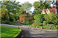
2
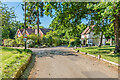
Clifton's Lane
Buildings in Clifton's Lane, with Colley Orchard and Willow Down Cottage on the left and The Lodge (see Image) on the right.
Image: © Ian Capper
Taken: 30 May 2020
0.02 miles
3
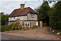
The Lodge
Lodge to Colley Corner, formed out of a late 16th Century cottage, with modern southern extension (the nearer part). Grade II listed - see www.historicengland.org.uk/listing/the-list/list-entry/1377959.
Image: © Ian Capper
Taken: 15 Sep 2012
0.03 miles
4
The Lodge
Late 16th Century house, with modern southern extension (the nearer part). Grade II listed - see www.historicengland.org.uk/listing/the-list/list-entry/1377959.
Image: © Ian Capper
Taken: 13 Apr 2020
0.03 miles
5
Footpath at rear of Buckland Edge
Footpath Reigate 24 from Reigate Heath to Buckland Green threads its way behind gardens and through a kitchen garden.
Image: © Hugh Craddock
Taken: 19 Oct 2009
0.04 miles
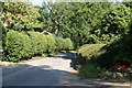
6
Side turning off Clifton's Lane
This appears to have been built in late Victorian times as a rather direct route towards Dorking, bypassing a sinuous section of the main Reigate - Dorking road. Since then it has been severed by sand pits and is a dead-end. It does not seem to have any public status.
Image: © Robin Webster
Taken: 27 Oct 2010
0.05 miles
7
Reigate: Clifton's Lane
Looking north. This is a byway open to all traffic, but there is no through road at the northern end.
Image: © Dr Neil Clifton
Taken: 26 Aug 2013
0.10 miles
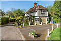
8
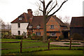
The Old Manor
A beautiful Grade II* listed house on the rural edge of Reigate, the original part of which dates from the 15th century, with the cross wing on the right being mid/late 16th century and the extension to the left being 18th century.
For listing particulars see www.historicengland.org.uk/listing/the-list/list-entry/1029144. The barn to the right is 16th century and is Grade II listed.
Image: © Ian Capper
Taken: 20 Jan 2008
0.10 miles
9
The Old Manor
A beautiful Grade II* listed house on the rural edge of Reigate, the original part of which dates from the 15th century, with the cross wing on the right being mid/late 16th century and the extension to the left being 18th century.
For listing particulars see www.historicengland.org.uk/listing/the-list/list-entry/1029144.
Image: © Ian Capper
Taken: 24 Mar 2012
0.10 miles
10
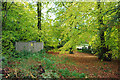
Footpath 475 nears Clifton's Lane
With a garden refuse heap and a small electricity sub-station at the left, the footpath follows the leafy way under the arched branches.
Image: © Robin Webster
Taken: 27 Oct 2010
0.10 miles