IMAGES TAKEN NEAR TO
Ravenscroft, PULBOROUGH, RH20 4EH
Introduction
This page details the photographs taken nearby to Ravenscroft, RH20 4EH by members of the Geograph project.
The Geograph project started in 2005 with the aim of publishing, organising and preserving representative images for every square kilometre of Great Britain, Ireland and the Isle of Man.

There are currently over 7.5m images from over14,400 individuals and you can help contribute to the project by visiting https://www.geograph.org.uk
Image Map (Loading...)


Getting Data...Please wait
Leaflet Map data © OpenStreetMap
Images are licensed for reuse under creativecommons.org/licenses/by-sa/2.0
Notes
- Clicking on the map will re-center to the selected point.
- The higher the marker number, the further away the image location is from the centre of the postcode.
Image Listing (77 Images Found)
Images are licensed for reuse under creativecommons.org/licenses/by-sa/2.0
Image
Details
Distance
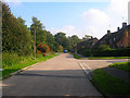
1
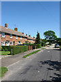
Ravenscroft
Housing estate on the southern edge of Storrington.
Image: © Simon Carey
Taken: 30 May 2009
0.05 miles
3
Browns Lane
The older lane becomes the newer Meadowside further down the road. Housing estate built on the southern side of the Storrington's High Street.
Image: © Simon Carey
Taken: 30 May 2009
0.09 miles
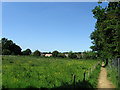
4
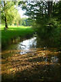
River Stor
Between the loop of Meadowside is a small open space also known as Meadowside through which the River Stor runs.
Image: © Simon Carey
Taken: 11 Oct 2008
0.09 miles
5
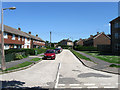
Meadowside
Post war housing estate in Storrington. The road heads south east crosses the River Stor then turns westwards before becoming Browns Lane. The junction is with Ravenscroft a 1960s housing estate.
Image: © Simon Carey
Taken: 11 Oct 2008
0.09 miles
6
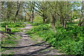
Diverted Footpath
Abbey House is currently being redeveloped so the footpath that ran through its grounds has now been diverted into the field next to it and been given an all weather surface to boot. Beyond the fence at the end of the field are Storrington's allotments.
Image: © Simon Carey
Taken: 30 May 2009
0.10 miles
7
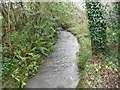
River Stor: Downstream of the Chantry Lane bridge
The Stor is a comparatively short river, running off the South Downs to flow northwards through Storrington, before joining the River Arun to the south-east of Pulborough. This is the view from Image]
Image: © Nigel Cox
Taken: 24 Jan 2016
0.13 miles
8
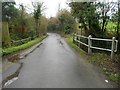
Storrington: Chantry Lane bridge
The bridge carries the lane over the River Stor. Please see Image] for the view of the river from the bridge.
Old Ordnance Survey 1:25,000 scale maps show that the Civil Parish boundary between Storrington and Sullington ran, and indeed probably still does run, down the centre of the lane here, the former to the right, the latter to the left.
Image: © Nigel Cox
Taken: 24 Jan 2016
0.14 miles
9
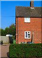
How Much is that Doggie in the Window?
No woof woof though, just seemed content to stand there and stare out at the world outside. The house concerned is in Meadowside.
Image: © Simon Carey
Taken: 11 Oct 2008
0.14 miles
10
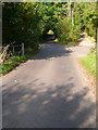
Chantry Lane
Possibly an old droving road as it begins on Chantry Hill then heads northwards to the A283 then continues as other lanes towards what was once Chiltington Common. Here it is crossing the River Stor.
Image: © Simon Carey
Taken: 11 Oct 2008
0.15 miles