IMAGES TAKEN NEAR TO
Frankland Mead, PULBOROUGH, RH20 4BD
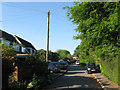
Introduction
This page details the photographs taken nearby to Frankland Mead, RH20 4BD by members of the Geograph project.
The Geograph project started in 2005 with the aim of publishing, organising and preserving representative images for every square kilometre of Great Britain, Ireland and the Isle of Man.

There are currently over 7.5m images from over14,400 individuals and you can help contribute to the project by visiting https://www.geograph.org.uk
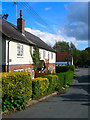
Image Map (Loading...)


Getting Data...Please wait
Leaflet Map data © OpenStreetMap
Images are licensed for reuse under creativecommons.org/licenses/by-sa/2.0
Notes
- Clicking on the map will re-center to the selected point.
- The higher the marker number, the further away the image location is from the centre of the postcode.
Image Listing (117 Images Found)
Images are licensed for reuse under creativecommons.org/licenses/by-sa/2.0
Image
Details
Distance
1

Franklands Arms
Frequently used by walkers of the South Downs Way
Image: © Dave Spicer
Taken: 1 Aug 2009
0.03 miles
2
The Holt
A small cul de sac built south of School Lane during the 1950s.
Image: © Simon Carey
Taken: 27 May 2013
0.03 miles
3
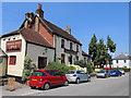
The Frankland Arms, Washington
A 200 year old coaching in that serves a nice pint of Doom Bar
Image: © Richard Rogerson
Taken: 21 Jul 2013
0.04 miles
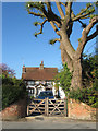
4
Frankland Arms
Located at the junction of Washington Bostal and School Lane. The inn was built in 1814 primarily to serve travellers using the turnpikes that ran north-south and east-west.
Image: © Simon Carey
Taken: 27 May 2013
0.05 miles
5
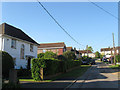
Chanctonbury Close
The southern end of the cul de sac was originally built as a council estate at the end of the 1940s. The close lies off School Lane.
Image: © Simon Carey
Taken: 27 May 2013
0.05 miles
6
Cottages, School Lane
The nearest is Brook Cottage and the middle is Old Barn Cottage which may suggest the origin of this building. School Lane's junction with Washington Bostal can be seen in the distance.
Image: © Simon Carey
Taken: 2 Oct 2008
0.06 miles
7
The Old Forge
Located at the corner of School Lane and The Holt. The house dates from 1732 and the old smithy was once located in the north east corner of the current garden.
Image: © Simon Carey
Taken: 27 May 2013
0.06 miles
8
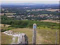
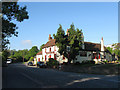
Downland village
This is a view of Washington in West Sussex. The bridleway is entering a disused chalk pit. Central to the skyline is Blackdown, which is the highest point in all Sussex. The headland on the horizon to the left of the picture is Bexleyhill but the picture quality is not sufficient to show the mast.
Image: © Shazz
Taken: 30 Jul 2010
0.06 miles
9
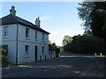
Brook House
Located at the junction of London Road and School Lane the house dates from 1830. The road on the right is the old course of The Pike, the road to Steyning, replaced in the late 1960s by the current layout.
Image: © Simon Carey
Taken: 27 May 2013
0.06 miles
10
The Leggs
The name of the field according to Washington's 1839 tithe map. Leggs or lags were often meadows abutting a watercourse, this one no exception with the small stream following the line of trees as it crosses from right to left.
Image: © Simon Carey
Taken: 27 May 2013
0.07 miles