IMAGES TAKEN NEAR TO
Garlands Road, REDHILL, RH1 6PR
Introduction
This page details the photographs taken nearby to Garlands Road, RH1 6PR by members of the Geograph project.
The Geograph project started in 2005 with the aim of publishing, organising and preserving representative images for every square kilometre of Great Britain, Ireland and the Isle of Man.

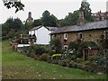
There are currently over 7.5m images from over14,400 individuals and you can help contribute to the project by visiting https://www.geograph.org.uk
Image Map
Images are licensed for reuse under creativecommons.org/licenses/by-sa/2.0
Notes
- Clicking on the map will re-center to the selected point.
- The higher the marker number, the further away the image location is from the centre of the postcode.
Image Listing (144 Images Found)
Images are licensed for reuse under creativecommons.org/licenses/by-sa/2.0
Image
Details
Distance
1
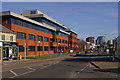
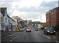
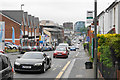
Brighton Road
Looking towards Redhill town centre, with the Reading Arch and Kingsgate in the background (see Image). The office block on the left is Furness House.
Image: © Ian Capper
Taken: 15 Mar 2009
0.05 miles
2
There was a crooked house ...
These buildings in Brighton Road seem to have a problem with their verticals and horizontals. On the high ground above is Ridgeway Road.
Image: © Ian Capper
Taken: 8 Mar 2009
0.06 miles
3
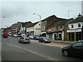
Brighton Road, Redhill
Dusk falls over Brighton Road, the A23 southern approach to Redhill.
Image: © Peter Kazmierczak
Taken: 26 Oct 2011
0.06 miles
4
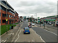
A23 Brighton Road, Redhill
Northwards towards the town centre.
Image: © Robin Webster
Taken: 23 Mar 2019
0.07 miles
5
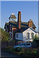
Ridgeway Road
Ridgeway Road appears on the 1871 large scale map, but with only a couple of houses built. More development took place over the next few decades, with the 1895 map showing it largely complete. This particular building with its unusual tower is locally listed.
Image: © Ian Capper
Taken: 27 Nov 2011
0.08 miles
6
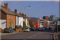
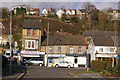
Brighton Road
Looking down Brighton Road towards central Redhill. The prominent office building in the background is Kingsgate (see Image for closer view).
Image: © Ian Capper
Taken: 8 Mar 2009
0.09 miles
7
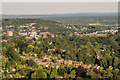
Redhill from Reigate Hill
Looking towards Redhill from Reigate Hill. Prominent features are the Dome on the left and the Redhill town centre office buildings on the left of RedCentral and Kingsgate to its right. Behind them is Redstone Hill and on the right is housing on Red Hill, which gave the town its name. In front of the office buildings is Wray Common Windmill and across the foreground are houses in the Raglan Road area of Reigate. In the far distance is the Weald near East Grinstead with the High Weald beyond.
Image: © Ian Capper
Taken: 29 Jun 2018
0.09 miles
8
Brighton Road, Redhill
A gentle slope down towards the town centre.
Image: © Bill Boaden
Taken: 17 May 2019
0.09 miles