IMAGES TAKEN NEAR TO
Brook Road, REDHILL, RH1 6DW
Introduction
This page details the photographs taken nearby to Brook Road, RH1 6DW by members of the Geograph project.
The Geograph project started in 2005 with the aim of publishing, organising and preserving representative images for every square kilometre of Great Britain, Ireland and the Isle of Man.

There are currently over 7.5m images from over14,400 individuals and you can help contribute to the project by visiting https://www.geograph.org.uk
Image Map
Images are licensed for reuse under creativecommons.org/licenses/by-sa/2.0
Notes
- Clicking on the map will re-center to the selected point.
- The higher the marker number, the further away the image location is from the centre of the postcode.
Image Listing (115 Images Found)
Images are licensed for reuse under creativecommons.org/licenses/by-sa/2.0
Image
Details
Distance
1
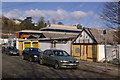
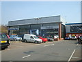
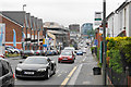
Brook Road
A group of small business premises line this part of the road. The modern offices behind are in Brighton Road.
Image: © Ian Capper
Taken: 8 Mar 2009
0.03 miles
2
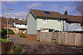
Gurney's Close
The name of this small development off Brook Road commemorates the Gurney family who were local benefactors. A possible connection with this particular road is that Redhill Brook, after which Brook Road is named and which has a short stretch in the open a few yards north of this close, is sometimes referred to as Gurney's Brook.
Image: © Ian Capper
Taken: 8 Mar 2009
0.06 miles
3
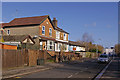
Brook Road
Named after the Redhill Brook, a small section of which is visible at the northern end, before disappearing in a culvert under the road and railway, and re-emering near Hooley Lane at the point shown in Image The pair of houses on the left have date plaques of 1904 (on the near one) and 1905 (on the one beyond).
Image: © Ian Capper
Taken: 8 Mar 2009
0.06 miles
4
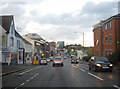
Brighton Road, Redhill
Dusk falls over Brighton Road, the A23 southern approach to Redhill.
Image: © Peter Kazmierczak
Taken: 26 Oct 2011
0.07 miles
6
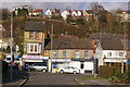
There was a crooked house ...
These buildings in Brighton Road seem to have a problem with their verticals and horizontals. On the high ground above is Ridgeway Road.
Image: © Ian Capper
Taken: 8 Mar 2009
0.08 miles
8
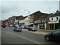
Brighton Road
Looking towards Redhill town centre, with the Reading Arch and Kingsgate in the background (see Image). The office block on the left is Furness House.
Image: © Ian Capper
Taken: 15 Mar 2009
0.08 miles
9
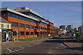
Brighton Road, Redhill
A gentle slope down towards the town centre.
Image: © Bill Boaden
Taken: 17 May 2019
0.09 miles
10
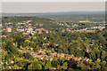
Redhill from Reigate Hill
Looking towards Redhill from Reigate Hill. Prominent features are the Dome on the left and the Redhill town centre office buildings on the left of RedCentral and Kingsgate to its right. Behind them is Redstone Hill and on the right is housing on Red Hill, which gave the town its name. In front of the office buildings is Wray Common Windmill and across the foreground are houses in the Raglan Road area of Reigate. In the far distance is the Weald near East Grinstead with the High Weald beyond.
Image: © Ian Capper
Taken: 29 Jun 2018
0.09 miles