IMAGES TAKEN NEAR TO
Centenary Way, HAYWARDS HEATH, RH16 4WN
Introduction
This page details the photographs taken nearby to Centenary Way, RH16 4WN by members of the Geograph project.
The Geograph project started in 2005 with the aim of publishing, organising and preserving representative images for every square kilometre of Great Britain, Ireland and the Isle of Man.

There are currently over 7.5m images from over14,400 individuals and you can help contribute to the project by visiting https://www.geograph.org.uk
Image Map
Images are licensed for reuse under creativecommons.org/licenses/by-sa/2.0
Notes
- Clicking on the map will re-center to the selected point.
- The higher the marker number, the further away the image location is from the centre of the postcode.
Image Listing (37 Images Found)
Images are licensed for reuse under creativecommons.org/licenses/by-sa/2.0
Image
Details
Distance
1
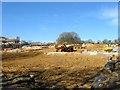
Four Acres (2)
The name of the field according to Cuckfield's 1843 tithe map that was merged with Image to the north and will soon disappear under the last phase of the Bolnore village development. Some hedgerow oaks have been retained as part of the development.
Image: © Simon Carey
Taken: 7 Mar 2015
0.01 miles
2
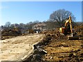
Four Acres (1)
The name of the field according to Cuckfield's 1843 tithe map that was merged with Image to the north and is now about to disappear under the last phase of the Bolnore village development. Some of the former hedgerow trees will remain as part of the new estate.
Image: © Simon Carey
Taken: 7 Mar 2015
0.03 miles
3
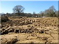
Mope Field
The name of the field according to Cuckfield's 1843 tithe map that was later merged with Image to the south and is now about to disappear under the last phase of the Bolnore village development.
Image: © Simon Carey
Taken: 7 Mar 2015
0.05 miles
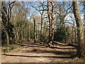
4
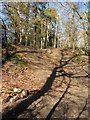
Railway Shaw
Now part of the Ashenground Wood nature reserve which has been formed from the rump of the former woodland to the west of the railway after the rest was uprooted to allow development of Bolnore village. Originally part of a field called Four Acres which ended up being the site of much deposited spoil from the cutting of the adjacent railway and subsequently being left to allow a small wood to grow.
Image: © Simon Carey
Taken: 7 Mar 2015
0.05 miles
5
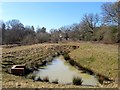
Pond Meadow
The name of the field given by the Friends of Ashenground and Bolnore Woods and part of the Ashenground Park nature reserve which has been formed from the remnants of the woods that have been felled to make way for the bolnore village development. On Cuckfield's 1843 tithe map it is called The Lag and its boggy nature has probably assisted in its survival where it is now used as drainage.
Image: © Simon Carey
Taken: 7 Mar 2015
0.08 miles
6
Railway Shaw
The name of the small wood given by the Friends of Ashenground and Bolnore Woods that is located on an embankment made from spoil from the time when the adjacent London-Brighton railway line was built. Now part of a local nature reserve that surrounds the new Bolnore development.
Image: © Simon Carey
Taken: 31 Mar 2015
0.10 miles
7
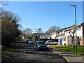
Climping Close, Haywards Heath
A cul de sac off Wealden Way that was built in the 1970s on a former field called Lower Meadow, according to Cuckfield's 1843 tithe map, that had once belonged to Great Haywards Farm. To the south is Image which is in the process of being built on as part of the bolnore village development.
Image: © Simon Carey
Taken: 7 Mar 2015
0.10 miles
8
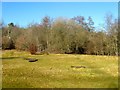
Four Acre Wood
An open area within the woodland that will not be developed as it was discovered the wood was ancient woodland.
Image: © Simon Carey
Taken: 17 Feb 2015
0.11 miles
9
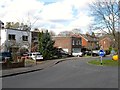
66-70, Sunnywood Drive, Haywards Heath
Designed and built by Lubetkin and Tecton, architects of the Gorilla House and Penguin Pool at London Zoo, between 1934-36 for what was a prospective estate that never materialised. There are eight houses in total and are listed as a good example of modernist architecture. Numbers 68-70 are the only semi-detached houses in the set. Number 72 is to the left out of shot is also part of the group but has had a roof added and is the only one of the eight not listed. See Image The eight houses surround a small island in Sunnywood Drive the rest of which was developed in a more conservative style in the late 1940s.
Image: © Simon Carey
Taken: 31 Mar 2015
0.11 miles
10
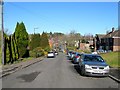
Sunnywood Drive, Haywards Heath
A residential road linking Ashenground Road to Wood Ride located on the former site of Great Haywards Wood. It began to be developed in the 1930s but only the houses surrounding the small roundabout at the foot of the slope were completed before the Second World War ceased development. Work recommenced around 1947 with much of the road completed by the 1950s.
Image: © Simon Carey
Taken: 17 Feb 2015
0.12 miles