IMAGES TAKEN NEAR TO
Fox Hill Close, HAYWARDS HEATH, RH16 4RA
Introduction
This page details the photographs taken nearby to Fox Hill Close, RH16 4RA by members of the Geograph project.
The Geograph project started in 2005 with the aim of publishing, organising and preserving representative images for every square kilometre of Great Britain, Ireland and the Isle of Man.

There are currently over 7.5m images from over14,400 individuals and you can help contribute to the project by visiting https://www.geograph.org.uk
Image Map
Images are licensed for reuse under creativecommons.org/licenses/by-sa/2.0
Notes
- Clicking on the map will re-center to the selected point.
- The higher the marker number, the further away the image location is from the centre of the postcode.
Image Listing (35 Images Found)
Images are licensed for reuse under creativecommons.org/licenses/by-sa/2.0
Image
Details
Distance
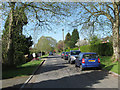
1
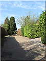
Fox Hill Close, Fox Hill
Small cul-de-sac off the B2112 built between the wars on a former field called Sycamore Field according to the 1843 Wivelsfield tithe map.
Image: © Simon Carey
Taken: 10 Apr 2011
0.01 miles
2
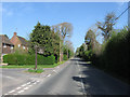
Fox Hill, Fox Hill
The name of the B2112 as it travels north towards Image as well as the small suburb that lines the western side. The road was originally known as Scrase's Hill after the farm that once occupied the site of Image but was changed after the war to its current name. The entrance to Image is on the left.
Image: © Simon Carey
Taken: 10 Apr 2011
0.03 miles
3
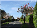
Weald Rise, Fox Hill
Developed in the 1960s on the former site of Scrase's Farm which had become a nursery in its last years.
Image: © Simon Carey
Taken: 10 Apr 2011
0.05 miles
4
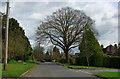
Fox Hill Village
A rather grand name for a residential close. If there ever were intended to be any communal facilities as befits a village, they are not at all evident.
Image: © Robin Webster
Taken: 1 Apr 2010
0.09 miles
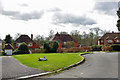
5
Fox Hill Village, Fox Hill
A cul-de-sac off the B2112 which was laid out in the late 1930s but other than one or two houses the rest of the road was not developed until after the war. According to Wivelsfield's tithe map of 1843 this was once Grove Field.
Image: © Simon Carey
Taken: 10 Apr 2011
0.09 miles
6
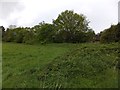
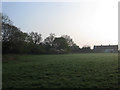
Field south of Fox Hill Village
The houses of the village are beyond the trees
Image: © David Smith
Taken: 1 May 2014
0.14 miles
7
The end of Fox Hill Village
The close terminates in a small roundabout to the right.
Image: © Robin Webster
Taken: 1 Apr 2010
0.14 miles
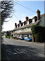
8
Houses on the south end of Haywards Heath
These houses are at Foxhill a suburb of Haywards Heath.
Image: © Dave Spicer
Taken: 15 May 2011
0.15 miles
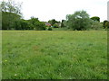
9
Scrases Mead
The name of the field according to Wivelsfield's 1843 tithe map. The row of houses at the far end of the field are the rear of Image Scrase was the name of a nearby local farm that disappeared with the development of the Fox Hill suburb of Haywards Heath.
Image: © Simon Carey
Taken: 17 Apr 2011
0.16 miles
10
Scrase Hill Terrace, Fox Hill
Built in the first decade of the 20th century on what is now the B2112. The road's original name was Scrase's Hill but was changed to its current one, Fox Hill, after the Second World War.
Image: © Simon Carey
Taken: 10 Apr 2011
0.16 miles