IMAGES TAKEN NEAR TO
The Welkin, HAYWARDS HEATH, RH16 2PW
Introduction
This page details the photographs taken nearby to The Welkin, RH16 2PW by members of the Geograph project.
The Geograph project started in 2005 with the aim of publishing, organising and preserving representative images for every square kilometre of Great Britain, Ireland and the Isle of Man.

There are currently over 7.5m images from over14,400 individuals and you can help contribute to the project by visiting https://www.geograph.org.uk
Image Map
Images are licensed for reuse under creativecommons.org/licenses/by-sa/2.0
Notes
- Clicking on the map will re-center to the selected point.
- The higher the marker number, the further away the image location is from the centre of the postcode.
Image Listing (187 Images Found)
Images are licensed for reuse under creativecommons.org/licenses/by-sa/2.0
Image
Details
Distance
1
145-147, High Street, Lindfield
Set back from the High Street the buildings were originally a school built by the local vicar during the mid 19th century. After the vicar's death the parish decided against keeping it and was sold to the County Towns Mission who remained here until 1937 when they sold it back to the parish. The former Mission Hall was subdivided and is now three residences, 145 is the sandstone hall type structure on the left, 147 is the main building to the right whilst out of shot to the right is Image See also Image, the original school masters house.
Image: © Simon Carey
Taken: 30 Aug 2015
0.05 miles
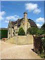
2
149, High Street, Lindfield
Set back from the High Street the imposing sandstone building is one of two dwellings that occupy what was originally a school built by the local vicar during the mid 19th century. After the vicar's death the parish decided against keeping it and was sold to the County Towns Mission who remained here until 1937 when they sold it back to the parish. The former Mission Hall was subdivided and is now three residences, see Image See also, Image
Image: © Simon Carey
Taken: 18 Jul 2015
0.05 miles
3
151, High Street, Lindfield
Built at the same time as neighbouring Image originally as a purpose built school masters house, it later became the Mission House before being sold to the parish in 1937. Now a private dwelling which is also known as St John's Lodge.
Image: © Simon Carey
Taken: 18 Jul 2015
0.05 miles
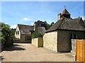
4
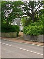
The Vicarage, High Street, Lindfield
Built in the late Victorian period and acquired by the church for its current use in 1939. Located off a long drive which is also a public footpath, see Image With the footpath continuing on towards Image where it follows another drive to Hickman's Lane.
Image: © Simon Carey
Taken: 6 Sep 2015
0.05 miles
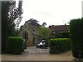
5
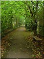
Footpath to The Welkin, Lindfield
Connecting the High Street to the Welkin estate. Another footpath is located to the immediate south of the trees on the left and heads to Hickmans Lane, see Image Originally the entrance to a large Victorian house called The Welkin which was demolished in the early 1960s and replaced by an estate of the same name.
Image: © Simon Carey
Taken: 30 Aug 2015
0.06 miles
6
141-143, High Street, Lindfield
Originally a single residence called Townlands dating from the 17th century that was refronted with mathematical tiling in the early 19th century. Sometime between 1910 and 1937 the building was split into two residences with the smaller southern part now known as Green Orchard and numbered 141 whilst the remainder has retained the original name and is now number 143.
As the road passes round the church the layout of the residences changes as they begin to be set back from the road and partly obscured by hedges.
Image: © Simon Carey
Taken: 30 Aug 2015
0.06 miles
7
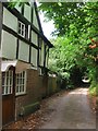
Footpath to Hickman's Lane, Lindfield
Heading west off High Street next to Image along a drive to Image beyond which it continues as a path until meeting another drive that links Image to the highway. Running parallel to the immediate north is another footpath, see Image
Image: © Simon Carey
Taken: 6 Sep 2015
0.06 miles
8
Picturesque garden in the High Street Lindfield
Image: © Dave Spicer
Taken: 6 Jun 2009
0.06 miles
9
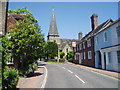
All Saints Church
Lindfield' Anglican church which is in the Diocese of Chichester. The house to the right next to the church is The Tiger. Formerly a public house, this is now the church hall
Image: © Nigel Freeman
Taken: 12 Jul 2005
0.07 miles
10
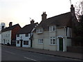
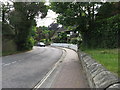
Houses opposite All Saints, Lindfield
(taken in the High Street)
Image: © Basher Eyre
Taken: 25 Mar 2015
0.07 miles