IMAGES TAKEN NEAR TO
Newton Road, HAYWARDS HEATH, RH16 2ND
Introduction
This page details the photographs taken nearby to Newton Road, RH16 2ND by members of the Geograph project.
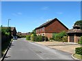
The Geograph project started in 2005 with the aim of publishing, organising and preserving representative images for every square kilometre of Great Britain, Ireland and the Isle of Man.

There are currently over 7.5m images from over14,400 individuals and you can help contribute to the project by visiting https://www.geograph.org.uk
Image Map
Images are licensed for reuse under creativecommons.org/licenses/by-sa/2.0
Notes
- Clicking on the map will re-center to the selected point.
- The higher the marker number, the further away the image location is from the centre of the postcode.
Image Listing (169 Images Found)
Images are licensed for reuse under creativecommons.org/licenses/by-sa/2.0
Image
Details
Distance
1
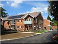
Duke Barn Court, Lindfield
The original Dukes Barn Court was built in 1975 as retirement flats but were demolished in the last year and replaced by another set of flats as well as seven individual houses, three of which can be seen on the right, with the other four behind the flats, see Image The original flats were named after a former barn that existed here from the 19th century until the 1950s when it was engulfed in residential expansion.
Image: © Simon Carey
Taken: 6 Sep 2015
0.04 miles
2
Duke Barn Mews, Lindfield
New houses nearing completion on the footpath that links Chaloner's Road to Alma Road. Part of a development erected on the former Dukes Barn Court, itself built in 1975 as retirement flats, that includes seven houses and a smaller block of flats that retains the original name, see Image Prior to the retirement flats this was indeed the site of Dukes Barn which survived into the 1950s.
Image: © Simon Carey
Taken: 6 Sep 2015
0.05 miles
3
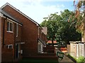
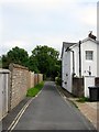
Lindfield Evangelical Free Church, Chaloner's Road, Lindfield
Originally located at Image moving to this building in 1939 where they have been ever since. Part of the County Towns Mission to begin with they changed to their current name in 1980. Chaloner's Road was developed between the wars and runs from Lewes Road to Newton Road.
Image: © Simon Carey
Taken: 4 Aug 2015
0.07 miles
4
Dukes Road, Lindfield
Running in an arc from Newton Road to Brushes Lane and developed sometime between 1955-62 on the site of two former fields called Great Tainter Mead and Upper Tainter Mead according to Lindfield's 1845 tithe map. The word tainter appears to be a corruption of tenter and evidence that a cloth industry was once established here (there is also a Fulling Mill Farm to the north of the village near the river). Cloth from the fulling mill was fixed to frames in an open field called tenters to stretch, dry and straighten the weave. The road name derives from Dukes Barn which was situated on the southern side of the field and commemorated by a set of flats called Dukes Barn Court.
Image: © Simon Carey
Taken: 4 Aug 2015
0.07 miles
5
Harvest Close, Lindfield
A cul de sac off Luxford Road with properties exclusively for the 55+ age range only. Built on the site of a former nursery.
Image: © Simon Carey
Taken: 9 Aug 2015
0.09 miles
6
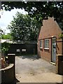
Telephone Exchange, Alma Road, Lindfield
Built in the early 1950s between the road and the green shed like building beyond which contains Lindfield Rifle Range who are celebrating their centenary in 2015.
Image: © Simon Carey
Taken: 6 Sep 2015
0.09 miles
7
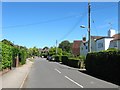
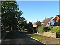
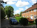
Luxford Road, Lindfield
A residential road that runs from Eastern Road to Newton Road that was laid out in the first decade of the 20th century and mostly completed by the Second World War.
Image: © Simon Carey
Taken: 9 Aug 2015
0.10 miles
8
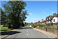
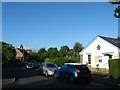
Lewes Road, Lindfield
Looking westwards along the B2111 from the junction with Eastern Road. The common is on the left.
Image: © Simon Carey
Taken: 9 Aug 2015
0.10 miles
9
Alma Road, Lindfield
A cul de sac off the High Street that given the name, was probably develop around or after the Crimean War of 1853-56. Alma Cottages are on the right and are a set of four that are at right angles to the road.
Image: © Simon Carey
Taken: 30 Aug 2015
0.10 miles
10
8-9, Alma Road, Lindfield
A view from the end of the road, though it continues as a footpath, back towards the High Street. The houses on the right were built sometime between 1947 and 1955.
Image: © Simon Carey
Taken: 6 Sep 2015
0.10 miles