IMAGES TAKEN NEAR TO
Higher Medrose, DELABOLE, PL33 9BP
Introduction
This page details the photographs taken nearby to Higher Medrose, PL33 9BP by members of the Geograph project.
The Geograph project started in 2005 with the aim of publishing, organising and preserving representative images for every square kilometre of Great Britain, Ireland and the Isle of Man.

There are currently over 7.5m images from over14,400 individuals and you can help contribute to the project by visiting https://www.geograph.org.uk
Image Map
Images are licensed for reuse under creativecommons.org/licenses/by-sa/2.0
Notes
- Clicking on the map will re-center to the selected point.
- The higher the marker number, the further away the image location is from the centre of the postcode.
Image Listing (14 Images Found)
Images are licensed for reuse under creativecommons.org/licenses/by-sa/2.0
Image
Details
Distance
1
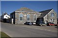
Delabole Methodist Church
This is one of at least three nonconformist churches of different denominations which were built at Delabole in the 19th century. The others have since closed as the denominations merged under the banner of the United Methodists.
Image: © Tony Atkin
Taken: 7 Mar 2010
0.06 miles
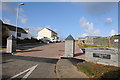
2
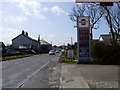
Delabole main road
Delabole's petrol station here is on its expanding northwestern end. The main road becomes too narrow further along in the distance and traffic sometimes has problems getting through.
Image: © William Bartlett
Taken: 28 Mar 2008
0.10 miles
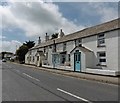
3
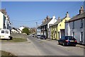
Delabole High Street
The smaller terraced houses on the right contrast with the slightly more upmarket bay-windowed terrace on the left.
Image: © Tony Atkin
Taken: 7 Mar 2010
0.11 miles
4
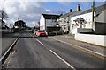
Delabole
The B3314 passing through the village of Delabole.
Image: © Philip Halling
Taken: 19 Feb 2012
0.12 miles
7
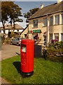
Delabole: the post office and postbox № PL33 31
The modern postbox is emptied finally at 5pm on weekdays and at 11:30am on Saturdays.
Image: © Chris Downer
Taken: 25 Aug 2009
0.19 miles
8
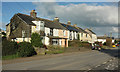
Terrace of houses, Delabole
A terrace of five, somewhat different in appearance from each other, seen across the B3314 in the southwest corner of the square.
Image: © Derek Harper
Taken: 5 Feb 2018
0.21 miles
9
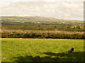
Delabole: field alongside post office
Looking across a field to the south of the post office, with fine views of the surrounding countryside.
Image: © Chris Downer
Taken: 25 Aug 2009
0.21 miles
10
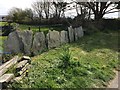
Slate field enclosure
The manor of Delabole (Deliou) was recorded in the Domesday Book (1086)
Delabole Slate, probably the finest slate available, has been used as a building material for over 600 years, and has been quarried since the early 17th century.
Image: © David Meredith
Taken: 13 Apr 2017
0.22 miles