IMAGES TAKEN NEAR TO
Austen Close, PAR, PL24 2FH
Introduction
This page details the photographs taken nearby to Austen Close, PL24 2FH by members of the Geograph project.
The Geograph project started in 2005 with the aim of publishing, organising and preserving representative images for every square kilometre of Great Britain, Ireland and the Isle of Man.

There are currently over 7.5m images from over14,400 individuals and you can help contribute to the project by visiting https://www.geograph.org.uk
Image Map (Loading...)


Getting Data...Please wait
Leaflet Map data © OpenStreetMap
Images are licensed for reuse under creativecommons.org/licenses/by-sa/2.0
Notes
- Clicking on the map will re-center to the selected point.
- The higher the marker number, the further away the image location is from the centre of the postcode.
Image Listing (22 Images Found)
Images are licensed for reuse under creativecommons.org/licenses/by-sa/2.0
Image
Details
Distance
1
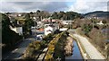
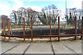
Road, Rail, Canal
Transportation links of various vintages running parallel towards the industrial waterfront at Par. This photograph was taken from a train on the main railway line crossing them all.
Image: © Tony Atkin
Taken: 5 Mar 2006
0.15 miles
2
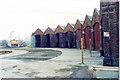
St Blazey (Par) railway depot
The depot consists of semicircular shed each part of which can be accessed via the turntable. Two Class 37 diesel locomotives wait between turns on china clay trains.
Image: © Roger Templeman
Taken: 17 Apr 1987
0.17 miles
7
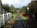
Railway heading north
Branch line from the china clay works towards par Station.
Looking north from the level crossing.
Image: © JThomas
Taken: 7 Nov 2014
0.19 miles
8
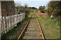
Old railway at Par
A view taken from the old level crossing just by the junction of the A3082 Par Green with Harbour Road, Par, and looking back up the spur in the direction of the main line. The spur runs to the China Clay Dries by Par docks but, as the china clay industry contracts, so the ripples spread outwards and this line now appears to have fallen into disuse.
Image: © John Gibson
Taken: 16 Mar 2009
0.19 miles
9
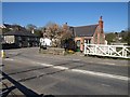
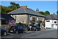
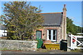
Cottage, level crossing, Par
Another view of the level crossing shown in Image, with the Cornwall Minerals Railway line emerging from the china clay works, having passed under the bridge shown in Image The cottage was presumably used by the level crossing attendant. In the background is the Par Inn.
Image: © Derek Harper
Taken: 2 Apr 2009
0.19 miles
10
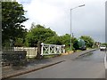
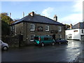
Par Bridge Level Crossing
On the little used line from St. Blazey to Par Harbour, Par Bridge Level Crossing is 252 miles and 44 chains from the London Paddington station zero point, measured via Box and Bristol. The level crossing is unusual in having the hand operated gates folded back against each other either side of the A3082 road when closed to the railway. This is because the A3082 road is much wider here than the railway formation and four gates are required to close the road.
There is a green National Trust van parked beyond the crossing.
Image: © Adrian Taylor
Taken: 16 May 2009
0.19 miles