1
The end of Beechcroft Road
One of three parallel roads named after trees, Beech, Cedar and Fir, arranged logically in alphabetical order running north from the road on which the photographer was standing. Unfortunately for the logic, there is Elmcroft some way away, out of sequence, and Oakcroft leads south, not north.
Image: © David Smith
Taken: 26 Sep 2014
0.19 miles
2
Old Boundary Marker on Beacon Park Road, Plymouth
Municipal Boundary Marker on the north side of Beacon Park Road, Plymouth, against the front garden wall of No. 151. Inscribed D.M.B. (Devonport Municipal Borough) / 4. Devonport borough was established in 1837 following the Municipal Corporations Act 1835.
Milestone Society National ID: DV_DMBB02pb
Image: © T Jenkinson
Taken: 21 Jul 2012
0.20 miles
3
Beacon Park Social Club, Plymouth
Image: © Roger Cornfoot
Taken: 2 Jan 2010
0.20 miles
4
Esso Garage, Outlands Road
A Saturday afternoon in April.
Image: © Anthony Vosper
Taken: 9 Apr 2016
0.20 miles
5
A386
Image: © N Chadwick
Taken: 28 Mar 2015
0.20 miles
6
A footpath off Lyndhurst Road, Plymouth
This wide path links Lyndhurst Road with Outland Road and Central Park. It is marked as a lane on old maps, and was presumably demoted to being a path to allow easier traffic flow on Outland Road, A386
Image: © David Smith
Taken: 26 Sep 2014
0.21 miles
7
Uphill, on Beacon Park Road
Image: © Roger Cornfoot
Taken: 2 Jan 2010
0.21 miles
8
New flats, on Beacon Park Road
Image: © Roger Cornfoot
Taken: 2 Jan 2010
0.21 miles
9
Bungalows, on Beacon Park Road, Plymouth
Image: © Roger Cornfoot
Taken: 2 Jan 2010
0.22 miles
10
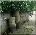
Old Boundary Markers on Beacon Park Road, Plymouth
Two boundary markers in Plymouth under a hedge and against a front garden wall on the north side of the junction of Beacon Park Road and Fircroft Road.
On the left is Municipal Boundary Marker DV_DMBB01pb. Inscribed with an upwards pointing arrow and D.M.B. / 5 / 10.S for Devonport Municipal Borough.
On the right is Parish Boundary Marker DV_WPBS01pb. Inscribed WESTON / P for Weston Peverell parish.
Image: © T Jenkinson
Taken: 21 Jul 2012
0.22 miles


