IMAGES TAKEN NEAR TO
Crescent Road, IVYBRIDGE, PL21 0AG
Introduction
This page details the photographs taken nearby to Crescent Road, PL21 0AG by members of the Geograph project.
The Geograph project started in 2005 with the aim of publishing, organising and preserving representative images for every square kilometre of Great Britain, Ireland and the Isle of Man.

There are currently over 7.5m images from over14,400 individuals and you can help contribute to the project by visiting https://www.geograph.org.uk
Image Map
Images are licensed for reuse under creativecommons.org/licenses/by-sa/2.0
Notes
- Clicking on the map will re-center to the selected point.
- The higher the marker number, the further away the image location is from the centre of the postcode.
Image Listing (75 Images Found)
Images are licensed for reuse under creativecommons.org/licenses/by-sa/2.0
Image
Details
Distance
2
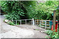
Kissing Gate at one entrance to Pithill or Erme Woods
Image: © jeff collins
Taken: 12 Jul 2008
0.06 miles
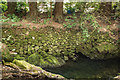
3
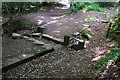
Old Leat
Further down the path the Leat is clearly visible, here the water could be diverted back into the river using the small sluish gate part of which is still in place, or allowed to carry on down the leat.
Image: © jeff collins
Taken: 21 Aug 2013
0.06 miles
4
River Erme
Near the Ivybridge Viaducts. My GPS was thoroughly disoriented by the depth of the wooded valley here and its reading makes no sense. It's possible I have this in the wrong square. Something to try and resolve on a future visit.
Image: © Derek Harper
Taken: 13 Nov 2020
0.07 miles
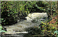
5
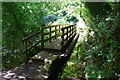
Footbridge by the Erme
Part of the old leat can be seen on the right of this bridge. The River Erme is just visible through the trees. This footbridge was built a few years ago after very heavy rain washed part of the footpath away.
Image: © jeff collins
Taken: 21 Aug 2013
0.07 miles
6
River Erme
Part of the man made bank of the River Erme as it enters Ivybridge.
Image: © Guy Wareham
Taken: 23 Mar 2016
0.07 miles
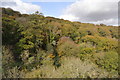
7
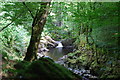
River Erme
A short distance down stream of the viaduct, the gorge cut out by the river gradually becomes deeper .
Image: © jeff collins
Taken: 21 Aug 2013
0.08 miles
8
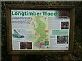
Map of Longtimber Woods, Ivybridge
A map showing the river and paths at the start of a woodland walk, with a short description of the railway viaduct
Image: © David Smith
Taken: 13 Dec 2021
0.08 miles
10
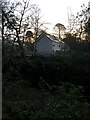
New Housing
The same development as Image Unseen between the camera position and the housing is the River Erme.
Image: © jeff collins
Taken: 7 Apr 2020
0.09 miles