IMAGES TAKEN NEAR TO
Stoke Climsland, CALLINGTON, PL17 8LL
Introduction
This page details the photographs taken nearby to PL17 8LL by members of the Geograph project.
The Geograph project started in 2005 with the aim of publishing, organising and preserving representative images for every square kilometre of Great Britain, Ireland and the Isle of Man.

There are currently over 7.5m images from over14,400 individuals and you can help contribute to the project by visiting https://www.geograph.org.uk
Image Map
Images are licensed for reuse under creativecommons.org/licenses/by-sa/2.0
Notes
- Clicking on the map will re-center to the selected point.
- The higher the marker number, the further away the image location is from the centre of the postcode.
Image Listing (16 Images Found)
Images are licensed for reuse under creativecommons.org/licenses/by-sa/2.0
Image
Details
Distance
1
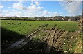
Field near Pempwell
This is probably sheep pasture, but evidence suggest the main four-legged animal currently in residence is the mole. The view is towards Higher Oldclims, the farmhouse right of centre, in Image, and described at http://list.historicengland.org.uk/resultsingle.aspx?uid=1291094&searchtype=mapsearch .
Image: © Derek Harper
Taken: 4 Mar 2015
0.12 miles
2
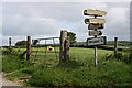
Dirty Signs
It looks like someone has had a go at cleaning the lower one but the higher signs are barely readable through years of accumulated dirt.
Image: © Tony Atkin
Taken: 19 May 2007
0.12 miles
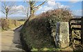
3
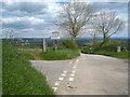
Minor road crossroads south of Pempwell
On the right of the photo is Image
Image: © Rod Allday
Taken: 13 May 2012
0.12 miles
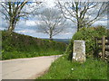
4

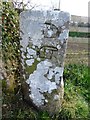
Old Guide Stone east of Lockington, Stokeclimsland parish
Carved stone fingerpost by the UC road, in parish of Stokeclimsland (North Cornwall District), Lockington, crossroads on Horsebridge road, by the road.
Inscription reads:-
Left face:
HORSEBRIDGE
{<-hand}
BRAY SHOP
{hand->}
Carved bench mark.
Right face:
BEALSHILL
{<-hand}
LUCKETT
{hand->}
Grade II listed.
List Entry Number: 1291115 https://historicengland.org.uk/listing/the-list/list-entry/1291115
Surveyed
Milestone Society National ID: CW_XSTOK1
Image: © Milestone Society
Taken: Unknown
0.13 miles
5
Old Guide Stone east of Lockington, Stokeclimsland parish
Carved stone fingerpost by the UC road, in parish of Stokeclimsland (North Cornwall District), Lockington, crossroads on Horsebridge road, by the road.
Inscription reads:-
Left face:
HORSEBRIDGE
{<-hand}
BRAY SHOP
{hand->}
Carved bench mark.
Right face:
BEALSHILL
{<-hand}
LUCKETT
{hand->}
Grade II listed.
List Entry Number: 1291115 https://historicengland.org.uk/listing/the-list/list-entry/1291115
Surveyed
Milestone Society National ID: CW_XSTOK1
Image: © Rosy Hanns
Taken: 27 Mar 2019
0.13 miles
6
Direction post near Pempwell
This direction post, quaintly inscribed with "clenched fist with pointing finger" for "each place-name" http://list.historicengland.org.uk/resultsingle.aspx?uid=1291115&searchtype=mapsearch is also shown in Image
Image: © Derek Harper
Taken: 4 Mar 2015
0.13 miles
7
Milestone on a crossroads near Pempwell
Grade II Listed - from the listing description: 'Probably mid-C19. Granite. Triangular section on rough base. Left face inscribed "HORSEBRIDGE" and "BRAY SHOP", right face inscribed "BEALSHILL" and "LUCKETT" each place-name having clenched fist with pointing finger indicating direction beneath.'
Image: © Rod Allday
Taken: 13 May 2012
0.14 miles
8
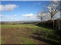
Field south of Pempwell
By a crossroads of lanes, also shown at http://www.geograph.org.uk/search.php?i=56755646 ; the field boundary on the right borders the lane to Horsebridge. Dim and distant is Dartmoor.
Image: © Derek Harper
Taken: 4 Mar 2015
0.16 miles
9
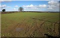
Field near Pempwell
On the other side of the lane from Image], with tyre tracks in the soft earth.
Image: © Derek Harper
Taken: 4 Mar 2015
0.16 miles
10
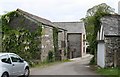
Converted Barns at Pempwell
It looks like these old farm buildings have been through a makeover. It is likely they are now holiday accommodation
Image: © Tony Atkin
Taken: 19 May 2007
0.19 miles