Old Guide Stone east of Lockington, Stokeclimsland parish
Introduction
The photograph on this page of Old Guide Stone east of Lockington, Stokeclimsland parish by Rosy Hanns as part of the Geograph project.
The Geograph project started in 2005 with the aim of publishing, organising and preserving representative images for every square kilometre of Great Britain, Ireland and the Isle of Man.

There are currently over 7.5m images from over 14,400 individuals and you can help contribute to the project by visiting https://www.geograph.org.uk
Old Guide Stone east of Lockington, Stokeclimsland parish
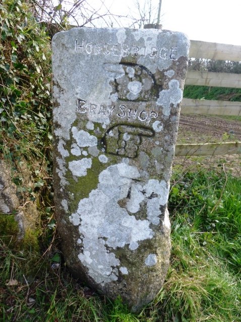
Image: © Rosy Hanns Taken: 27 Mar 2019
Carved stone fingerpost by the UC road, in parish of Stokeclimsland (North Cornwall District), Lockington, crossroads on Horsebridge road, by the road. Inscription reads:- Left face: HORSEBRIDGE {<-hand} BRAY SHOP {hand->} Carved bench mark. Right face: BEALSHILL {<-hand} LUCKETT {hand->} Grade II listed. List Entry Number: 1291115 https://historicengland.org.uk/listing/the-list/list-entry/1291115 Surveyed Milestone Society National ID: CW_XSTOK1
Images are licensed for reuse under creativecommons.org/licenses/by-sa/2.0
Image Location
Latitude
50.550294
Longitude
-4.296848