IMAGES TAKEN NEAR TO
Tremar, LISKEARD, PL14 5HQ
Introduction
This page details the photographs taken nearby to PL14 5HQ by members of the Geograph project.
The Geograph project started in 2005 with the aim of publishing, organising and preserving representative images for every square kilometre of Great Britain, Ireland and the Isle of Man.

There are currently over 7.5m images from over14,400 individuals and you can help contribute to the project by visiting https://www.geograph.org.uk
Image Map (Loading...)


Getting Data...Please wait
Leaflet Map data © OpenStreetMap
Images are licensed for reuse under creativecommons.org/licenses/by-sa/2.0
Notes
- Clicking on the map will re-center to the selected point.
- The higher the marker number, the further away the image location is from the centre of the postcode.
Image Listing (12 Images Found)
Images are licensed for reuse under creativecommons.org/licenses/by-sa/2.0
Image
Details
Distance
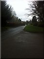
1
The South East access to Tremar Coombe
The South Eastern part of Tremar Coombe, the start of Tremar Common, still Common Land, although much of which has become difficult to access.
Image: © St Clarus
Taken: 21 Dec 2015
0.06 miles
2
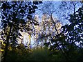
Autumn Sunset
The last rays of the setting sun pick out a line of tall trees, viewed from a small wooded area.
Image: © fotofun
Taken: 6 Oct 2012
0.07 miles
3
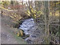
The Tremar Stream
A tributary of the River Seaton, this stream was used for tin streaming long before the discovery of copper which turned this rural common area into a small settlement to support the mineworkers and their families. Indeed, before this industrial expansion, around 1840, the village of Tremar Coombe simply did not exist. The only properties in the area shown on the Tithe map pre 1841, and located at Trecarne, some 250 yards north, are believed to be the homes of the Tremar Tin Streamers. The Tremar stream continues to flow gently down the valley, oblivious of the changes this area has experienced, is experiencing and will undoubtedly experience!
Image: © Eric Foster
Taken: 3 Feb 2012
0.08 miles
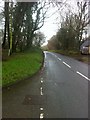
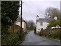
4
Unadopted road leading to Milk Lane
Unadopted road leading to properties adjacent to the track known locally as Milk Lane. The name Milk Lane is believed to derive from the use of it by the Milkman, possibly collecting milk from the former farm that before its demolition stood on the site now known as Venlands Manor. The farm was owned by the Hoskin family.
Image: © St Clarus
Taken: 21 Dec 2015
0.10 miles
5

Happy Honey Bee
Not a geograph, not technically brilliant but one of my most favourite photographs. Just pointed the camera and pressed the button and this happy little lady was preserved for ever. Well, until the lights all go out that is!
Image: © Eric Foster
Taken: 18 Jul 2009
0.10 miles
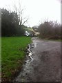
6
Road from Tremar Coombe to Lower Tremar
The Southern end of Tremar Coombe leading to Lower Tremar with part of Tremar Common on the right.
Image: © St Clarus
Taken: 21 Dec 2015
0.11 miles
7
Narrow lane into Tremar Coombe
Who ever built these two houses could not have realized the potential bottleneck it would cause when motor cars replaced other modes of transport. This now busy road leads into Tremar Coombe, the coombe meaning valley, and the Tre meaning homestead and mar possibly meaning mark. You then get the homestead of mark in the valley. Before the discovery of copper at Crows Nest nearby, Tremar was just a common, so before 1841 only a couple of dwellings existed on the old tithe map. Between 1841 and 1880 houses were built to support the mining industry, more modern houses later added to provide a mix of old and modern.
Image: © Eric Foster
Taken: 16 Mar 2008
0.12 miles
8
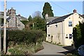
Lower Tremar
19th (or perhaps early 20th) century houses at the centre of the village.
Image: © Tony Atkin
Taken: 10 Mar 2007
0.16 miles
9
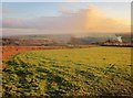
Field near Tremar
From a bend on the lane from Trethevy Quoit, which forms the boundary of the Cornwall and West Devon Mining Landscape. Someone in Tremar has a bonfire.
Image: © Derek Harper
Taken: 13 Dec 2014
0.23 miles
10
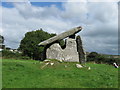
Trethevy Quoit, St Cleer, Cornwall
I apologise for submitting yet another picture of this ancient burial chamber, but I just wanted it to add to my profile. Sorry.
Image: © Derek Voller
Taken: 25 Sep 2010
0.24 miles