IMAGES TAKEN NEAR TO
Arkleston Road, PAISLEY, PA3 4HY
Introduction
This page details the photographs taken nearby to Arkleston Road, PA3 4HY by members of the Geograph project.
The Geograph project started in 2005 with the aim of publishing, organising and preserving representative images for every square kilometre of Great Britain, Ireland and the Isle of Man.

There are currently over 7.5m images from over14,400 individuals and you can help contribute to the project by visiting https://www.geograph.org.uk
Image Map
Images are licensed for reuse under creativecommons.org/licenses/by-sa/2.0
Notes
- Clicking on the map will re-center to the selected point.
- The higher the marker number, the further away the image location is from the centre of the postcode.
Image Listing (37 Images Found)
Images are licensed for reuse under creativecommons.org/licenses/by-sa/2.0
Image
Details
Distance
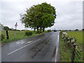
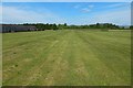
1
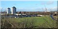
Playing field beside Arkleston Road
A Image leads to the point from which this picture was taken. No entirely unobstructed view was possible, but the elevated viewpoint does at least make for easier comparison with the map.
[See Image for a later (2018) view from within the playing field itself.]
The road on the right is Arkleston Road, and the houses on the left are in the Gallowhill area. The three high flats on the left are shown at Image and linked images.
The goalposts indicate the current use of the grassy space, but the area has an interesting history. The nearest part of it was formerly the site of two reservoirs, one centred on Image, and the other, immediately to the south-west of it, centred on Image They were not present when the first-edition OS map was surveyed in 1857, but they are on the second-edition map, revised in about 1895. They were in the area that appears in the foreground of this picture. Over to the right, on the near side of the road, was Arkleston Print Works, centred on Image (a rough indication of where the works stood in relation to this picture: from the further of the two goal posts, the site occupied by the works extended directly to the right, as far as to the main road).
The site was originally occupied by Walter Drybrough & Company, a yarn dyeing and yarn printing business. However, that company would later be taken over by another firm: Kerr & Co, manufacturers and finishers, in Paisley, was taken over by the Ross Family, who carried on the work of cloth finishers. Their business expanded rapidly, and they moved to a site on Seedhill Road in 1888, where they had built a new and larger finishing works. In addition to finishing cloth, they began, in 1908, dyeing it. To that end, they took over the aforementioned works of Walter Drybrough and Co at Arkleston, and carried on their cloth dyeing at that site, as "Seedhill Yarn Dyeing and Yarn Printing Co, Arkleston Works, Paisley". The company continued with the other side of their business at the existing Seedhill Road works, as "Seedhill Finishing Company, Ltd, dyers, mercerisers, printers and finishers, Ralston St, Seedhill Road, Paisley".
Just to the west of the reservoirs, the second-edition map shows two smaller and more irregular bodies of water, one at Image (just in front of the houses), the other at Image (now under some houses). Those pools are older than the reservoirs, as shown by their appearance on the first-edition OS map (surveyed in 1857). Their origin is not apparent from the OS maps alone. However, it turns out that they were once quarries.
A useful description of this area can be found on pages 273-276 of an issue of "The Geological Magazine" (New Series, Decade VI, Vol IV, January to December 1917). The article in question is by Peter MacNair, FRSE, FGS, and has the unpromising title "The Horizon of the Type-Specimens of Dr Scouler's Dithyrocaris tricornis and D testudinea". However, the article contains a useful geological description of the area shown in the present picture, with an accompanying map which shows the two irregular pools mentioned above; on that map, they are labelled "Old Quarries", and are shown to lie within an area of Gallowhill Limestone. The article's most relevant section is as follows:
"As has already been stated, no exposures of the Gallowhill Limestone can now be seen at any of the localities where it was formerly worked. But the position of two of the quarries south of Arkleston Print Works can still be seen. Another quarry appears to have been opened a little to the south of Gallowhill, opposite the Mote Hill. The positions of these quarries are indicated on the map, and they seem to have been somewhat extensively worked about the year 1835, when Scouler's fossils were found, the old Powder Magazine between Arkleston and South Arkleston having been built of it, as well as a large number of the dykes in the Gallowhill Policies. It was also used in some walls in the neighbourhood of the Paisley Barracks, where it can still be seen."
The location of the long-gone Arkleston Print Works was given above. On the location of the "Mote Hill" mentioned here, see Image The unqualified "Arkleston" refers to Arkleston House (now gone), formerly West Arkleston: see Image and Image for its former site, and Image for more information on the area as a whole.
The Image that was also mentioned in the quoted excerpt still stands. For "the old Powder Magazine" (no longer in existence), see Image; there was another quarry near that building: Image
Image: © Lairich Rig
Taken: 11 Jan 2014
0.04 miles
2
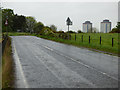
Arkleston Road
A well known rat-run road through farmland between The M8 Junction 27 and the east end of Paisley. Not recommended for walking due to the absence of a footpath.
Image: © Thomas Nugent
Taken: 15 May 2017
0.06 miles
3
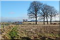
Beside Arkleston Road
Not far ahead is the corner of the road, as depicted on the OS map. The picture was taken from a Image The red car in the right background of that picture is at about the same place as the vehicles in the present picture. The large structure visible behind the tallest of the trees is part of Image (as seen by comparison with the far right of a picture of a Image).
Image: © Lairich Rig
Taken: 11 Jan 2014
0.06 miles
4
Field at Arkleston
See Image for more on this area. The present picture was taken from a field gate beside the road junction. The high flats in the background are two of three that stand alongside Image in the Gallowhill area: Image is on the left, and Image is on the right, hiding the third building (Image) from view.
The field shown in the present picture is just to the north of the area shown in Image It formerly contained an old quarry pit (see Image and the first link in the previous paragraph), but that pit has been filled in, and the ground levelled. There used to be a small building, a powder magazine, nearby: Image
Image: © Lairich Rig
Taken: 4 Nov 2013
0.07 miles
5
Arkleston Road
A well known rat-run road through farmland between The M8 Junction 27 and the east end of Paisley. Not recommended for walking due to the absence of a footpath.
Image: © Thomas Nugent
Taken: 15 May 2017
0.07 miles
6
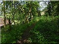
Path through the woods
See Image for a view in the opposite direction from about the same place. In the present picture, the building seen indistinctly in the left foreground is Montgomery Court (sheltered housing).
Directly ahead, at the foot of the slope, but partly hidden by the intervening trees, is a Image
Image: © Lairich Rig
Taken: 19 May 2018
0.08 miles
7
Former site of powder magazine
For comments on the area as a whole, see Image In the present picture, the house that can be seen just left of centre is part of Image, as is the large structure to its right.
From the first-edition map (surveyed c.1857) up to the revision of c.1911, a small building, a powder magazine, is depicted on OS mapping as standing on the north-western side of the road, at about Image The building had been cleared away before the Second World War; it is not depicted on the map revision of c.1939.
The building was made of Gallowhill Limestone. Although there was a quarry immediately to the NNW of the building (see Image), the stone perhaps came from two quarries (likewise long gone) that were a little further to the west, as explained at Image, where the former site of those quarries is shown.
The place where the powder magazine stood was just inside the edge of the field, slightly nearer than the house, and a little to its left. There is a tall wooden post about halfway between the house and the left-hand edge of the picture; the approximate former location of the powder magazine is just in front of where that pole is.
The powder magazine belonged to the Paisley Police Commissioners, and was "used as a store for Merchants' Powder". Presumably for safety reasons, to reduce the risk that any explosion would involve the entire stock of powder, the building was internally divided, probably by thick baffles: "there are nine small Compartments within the inclosure for storage of Powder" [OS Name Books].
At the far right of the picture is a gate at a corner of the field, at Image, where there is a road junction. Beyond the gate, some high ground (c.Image) near Byres Hill can be seen in the distance.
Image: © Lairich Rig
Taken: 11 Jan 2014
0.08 miles
8
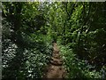
Path through the woods
See Image for a view in the opposite direction from about the same spot.
The path leads past, but not through, Image I interpret the path itself as following the line of a track that used to run past the western side of the house; see Image for further comments.
Image: © Lairich Rig
Taken: 19 May 2018
0.09 miles
9
Playing field beside Arkleston Road
See Image for an earlier and more distant view.
The point from which the present picture was taken was once the northern end of a reservoir. Not far ahead, on the right, was another reservoir.
Directly ahead, extending back from a point about halfway between the photographer's position and the road in the background, were the Arkleston Print Works. The works extended from there to the line of the road.
See the link in the first paragraph for more information about the works and the reservoirs. For the earlier history of the wider area, see Image
Image: © Lairich Rig
Taken: 19 May 2018
0.09 miles
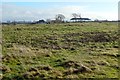
10
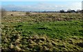
Former site of quarry
For comments on the area as a whole, see Image In the present view, the building on the right is Image
The disturbed area in the foreground is what the second-edition OS map (revised c.1895) labels an "old quarry"; it is shown there containing water. Just to the SSE of it, beside the road, the same map shows a small unlabelled building. The first-edition 6-inch map (surveyed in 1857) identifies that building as a powder magazine (see Image); the same map shows but does not label the quarry, which was not then filled with water.
The old quarry was clearly filled in long ago; few traces are visible today. The quarry is marked on an OS map revised about 1911, but not on one that was revised in about 1939.
An item about a Image discusses two old quarries (of a similar size) not far to the west, which, according to an old geology article cited there, are thought to have been worked for what was locally called Gallowhill Limestone (which, incidentally, was used to build the powder magazine).
As for the site shown in the present photograph, the geological map in the old article shows it lying at the edge of a band of "Hurlet Limestone and Coal". Not far to the south, a tunnel had been constructed for the railway; the geology of the area would therefore have had more than just a theoretical interest.
Image: © Lairich Rig
Taken: 11 Jan 2014
0.09 miles