IMAGES TAKEN NEAR TO
Waterperry Common, OXFORD, OX33 1LQ
Introduction
This page details the photographs taken nearby to Waterperry Common, OX33 1LQ by members of the Geograph project.
The Geograph project started in 2005 with the aim of publishing, organising and preserving representative images for every square kilometre of Great Britain, Ireland and the Isle of Man.

There are currently over 7.5m images from over14,400 individuals and you can help contribute to the project by visiting https://www.geograph.org.uk
Image Map
Images are licensed for reuse under creativecommons.org/licenses/by-sa/2.0
Notes
- Clicking on the map will re-center to the selected point.
- The higher the marker number, the further away the image location is from the centre of the postcode.
Image Listing (13 Images Found)
Images are licensed for reuse under creativecommons.org/licenses/by-sa/2.0
Image
Details
Distance
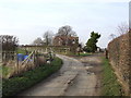
1
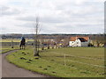
Parson's Farm near Waterperry
View from cattle grid and gate on track into the farm. The horseman asked me to open the gate for him.
Image: © David Hawgood
Taken: 20 Feb 2009
0.02 miles
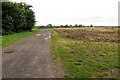
2
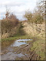
"Other route with public access" to Waterperry Common
This track probably has a right of access by motor vehicle - but you are not recommended to try. A local horseman told me it had not been used by vehicles for 20 years, and you could probably get through with a quad bike but not with a car. For routes like this, marked as "other route with public access" on the Ordnance Survey map, it is necessary to contact the highways authority to establish what rights exist. For the other end of the route see Image
Image: © David Hawgood
Taken: 20 Feb 2009
0.11 miles
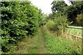
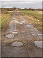
4
Path with confusing access right, near Waterperry
This path is marked on the map as "Other route with public access". The North end has an Oxfordshire County Council public footpath disk. The south end near Parsons Farm has an Oxfordshire County Council notice saying that cyclists must use this path rather than a public footpath which is the Oxfordshire Way at that point.
Image: © David Hawgood
Taken: 1 May 2009
0.13 miles
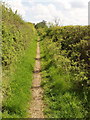
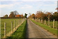
5
Track to Park Farm House
The Oxfordshire Way runs along the track.
Image: © Steve Daniels
Taken: 13 Sep 2013
0.14 miles
6
Davenport House near Parsons Farm
near to M40 Waterperry Common
Image: © al partington
Taken: 31 Jan 2006
0.15 miles
7
Smiths Lane up to Ledall Cottage
Smiths Lane (Oxfordshire Way) up to Ledall Cottage
Image: © Shaun Ferguson
Taken: 4 Nov 2007
0.15 miles
8
Oxfordshire Way to Park Farm House
The long distance footpath goes across the field on the track, then turns left onto another footpath in front of the house.
Image: © David Hawgood
Taken: 20 Feb 2009
0.15 miles
9
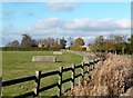
Horse Jumps near Ledalls Cottage
Beside the Oxfordshire Way footpath.
Image: © Des Blenkinsopp
Taken: 7 Nov 2012
0.17 miles
10
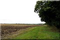
Field edge by Ledall Cottage
The footpath across the field has been ploughed up. The edge of the field has been left grassy for walkers.
Image: © Steve Daniels
Taken: 13 Sep 2013
0.18 miles