IMAGES TAKEN NEAR TO
Gosport Lane, BANBURY, OX17 1EG
Introduction
This page details the photographs taken nearby to Gosport Lane, OX17 1EG by members of the Geograph project.
The Geograph project started in 2005 with the aim of publishing, organising and preserving representative images for every square kilometre of Great Britain, Ireland and the Isle of Man.

There are currently over 7.5m images from over14,400 individuals and you can help contribute to the project by visiting https://www.geograph.org.uk
Image Map
Images are licensed for reuse under creativecommons.org/licenses/by-sa/2.0
Notes
- Clicking on the map will re-center to the selected point.
- The higher the marker number, the further away the image location is from the centre of the postcode.
Image Listing (4 Images Found)
Images are licensed for reuse under creativecommons.org/licenses/by-sa/2.0
Image
Details
Distance
1
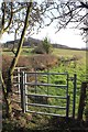
Footpath to Knowle End Wood
The footpath leaves the B4086 and heads uphill towards the wood.
Image: © David P Howard
Taken: 6 Mar 2012
0.11 miles
2
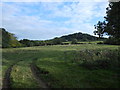
Edge Hill
This shows the northern end of the Edgehill escarpment at Knowle End which is the prominent wooded hill. The trees to the immediate left of the white house mark the line of the Edgehill Light Railway (EHLR) which ran up to the top of the hill via a rope powered 1 in 6 incline at that point. The railway was built to remove ironstone from quarries on the hill top but the project was a financial failure. The operation probably worked properly for only a few months (if at all) in the summer of 1922. In October of that year there was a fatal accident on the worked incline and the line was never repaired. Part of the lower section of the line was taken over by the MOD during the war. Most of the lower section of the line has been obliterated by Kineton munitions depot and the line of the railway can only clearly be seen in this area. Most of the track that remained and its locos and equipment were scrapped immediately after World War two and the company was wound up in 1957.
Image: © Nigel Mykura
Taken: 14 Sep 2012
0.12 miles
3
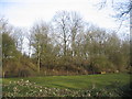
Edge Hill Light Railway embankment
This embankment is close to the point at which the line crossed the road to Radway and is still shown on modern OS maps. This three mile long standard gauge line was built for the Oxfordshire Ironstone Company in 1920 and ran from a junction with the Stratford-on-Avon & Midland Junction Railway at Burton Dassett to ironstone mines at Edge Hill around Image It was only operated for five years before the iron ores ran out and the line was closed. The railway and its rolling stock lay derelict for another 22 years before it was dismantled. The 1940s map still shows the line as being in existence. See also http://www.hfstephens-museum.org.uk/pages/his_railways/edgehill.htm
Image: © David Stowell
Taken: 22 Jan 2006
0.22 miles
4
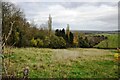
Edge Hill inclined plane
The trees mark the route of the Edge Hill Light Railway inclined plane. This was a rope-worked incline used to take wagons up and down from ironstone quarries at the top of Edge Hill to Burton Dassett sidings on the Stratford & Midland Junction Railway. The line closed almost as soon as it was opened in the 1920's due to the changes in ironstone mining after WW1. It lay dormant in a timewarp until it was dismantled in 1946.
Image: © Bob Walters
Taken: 11 Nov 2022
0.23 miles