IMAGES TAKEN NEAR TO
Papist Way, WALLINGFORD, OX10 9QH
Introduction
This page details the photographs taken nearby to Papist Way, OX10 9QH by members of the Geograph project.
The Geograph project started in 2005 with the aim of publishing, organising and preserving representative images for every square kilometre of Great Britain, Ireland and the Isle of Man.

There are currently over 7.5m images from over14,400 individuals and you can help contribute to the project by visiting https://www.geograph.org.uk
Image Map (Loading...)


Getting Data...Please wait
Leaflet Map data © OpenStreetMap
Images are licensed for reuse under creativecommons.org/licenses/by-sa/2.0
Notes
- Clicking on the map will re-center to the selected point.
- The higher the marker number, the further away the image location is from the centre of the postcode.
Image Listing (300 Images Found)
Images are licensed for reuse under creativecommons.org/licenses/by-sa/2.0
Image
Details
Distance
1

Papist Way, Cholsey
Papist Way in Cholsey provides a link to the railway station from the River Thames
Image: © Philip Halling
Taken: 4 Jul 2011
0.03 miles
2
Downside
A new development in the village built on an old smallholding. The road was built through the site of a bungalow that was built in the 1950s.
Image: © Bill Nicholls
Taken: 18 Jan 2009
0.04 miles
3
Celsea Place, Cholsey
Celsea Place off Papist Way in Cholsey.
Image: © Philip Halling
Taken: 4 Jul 2011
0.05 miles
4
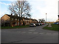
Houses on Papist way
View from the old track to silly bridge towards the back of the houses on Papist Way Cholsey
Image: © Bill Nicholls
Taken: 7 Apr 2019
0.05 miles
5
Celsea Place
This is a road of old hospital housing built back in the 1960s. I think the ends are prefabricated sections. Had a few friends live round here. The properties are owned by the housing association now.
Image: © Bill Nicholls
Taken: 9 Mar 2008
0.06 miles
6
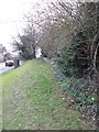
This was a footpath
This used to be a footpath leading past the houses but it has fallen into disuse and the grass has grown over the concrete losing it from view.
Image: © Bill Nicholls
Taken: 20 Feb 2011
0.06 miles
7

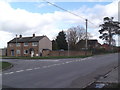
Papist Way, Cholsey
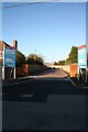
Papist Way is seen here at its junction with Celsea Place, on the south eastern edge of Cholsey village. The name 'Papist Way' is unusual and is believed to derive from the Hildesley family who occupied Littlestoke Manor in the 17th century. The Hildesleys were recusant Catholics (that is they refused to attend Church of England services, remaining loyal to the Roman Catholic faith after the reformation) and would have used this route to reach their house via a ferry across the River Thames. There is no ferry here now but the continuation of Papist Way down to the river is called Ferry Lane. Papist was used as a derogatory term and it seems likely that the people of Cholsey were not fond of their neighbours over the water.
Image: © Stephen McKay
Taken: 4 May 2022
0.06 miles
8
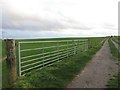
Gate beside the Track
The gate and fenced off area are relatively new and fence off the cropped field so it can get used for livestock as well. The area beside the gate used to be known locally as the pit and was an old chalk quarry where the local kids played. It was filled in many years ago
Image: © Bill Nicholls
Taken: 31 Dec 2015
0.07 miles
9
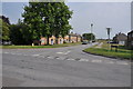
Papist Way, Cholsey
At the junction with Celsea Place
Image: © Robin Sones
Taken: 21 Feb 2014
0.07 miles
10
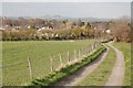
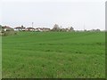
Farm track south of Cholsey village
This farm track leading north to Honey Lane, Cholsey (SU5886) lies on the line of the Roman road from Silchester near Reading to Dorchester-on-Thames. Cholsey church's tower is just visible top left and Wittenham Clumps (SU5692) can be seen in the far distance (7kms away). The Roman road crossed the hill on the horizon just to the right of the single tree.
Image: © Gerry Lewis
Taken: 21 Mar 2007
0.07 miles