IMAGES TAKEN NEAR TO
Grants Close, LONDON, NW7 1DE
Introduction
This page details the photographs taken nearby to Grants Close, NW7 1DE by members of the Geograph project.
The Geograph project started in 2005 with the aim of publishing, organising and preserving representative images for every square kilometre of Great Britain, Ireland and the Isle of Man.

There are currently over 7.5m images from over14,400 individuals and you can help contribute to the project by visiting https://www.geograph.org.uk
Image Map
Images are licensed for reuse under creativecommons.org/licenses/by-sa/2.0
Notes
- Clicking on the map will re-center to the selected point.
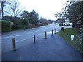
- The higher the marker number, the further away the image location is from the centre of the postcode.
Image Listing (87 Images Found)
Images are licensed for reuse under creativecommons.org/licenses/by-sa/2.0
Image
Details
Distance
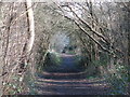
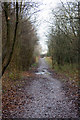
2
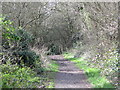
The course of the former Mill Hill East to Edgware railway line between Sanders Lane and Devonshire Road
See Image
Image: © Mike Quinn
Taken: 26 Feb 2020
0.05 miles
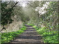
4
Path along abandoned railway line, Mill Hill
This line, part of the Great Northern Railway's suburban network, ran from Mill Hill East to Edgware. When the London Underground's Northern Line took over much of that network it was proposed that this would become part of a web of lines that offered two routes to Edgware and eventually an extension on in the direction of Elstree, but the Second World War led to the abandonment of the plan and of this line.
Although the line was never electrified, preparations took place and along the right side of the path can be seen regular concrete posts that would have carried the power cables.
Image: © Christopher Hilton
Taken: 19 Apr 2017
0.05 miles
5
The course of the former Mill Hill East to Edgware railway line between Sanders Lane and Devonshire Road (3)
See Image
Image: © Mike Quinn
Taken: 26 Feb 2020
0.05 miles
6
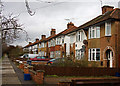
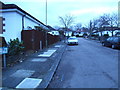
Housing on Devonshire Road
Devonshire road was part of the expansion of the area in the 1930's. I am unsure whether these semi-detached houses with their circular porch design belong to that period or are post war.
Image: © Martin Addison
Taken: 19 Jan 2009
0.06 miles
7
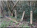
Cable posts by the former Mill Hill East to Edgware railway line
See Image
Image: © Mike Quinn
Taken: 26 Feb 2020
0.06 miles
8
The course of the former Mill Hill East to Edgware railway line west of Sanders Lane
See Image
Image: © Mike Quinn
Taken: 26 Feb 2020
0.06 miles
9
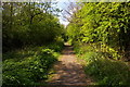
Beyond Mill Hill East
Looking back again towards the Sanders Lane bridge near Mill Hill East. The sudden change of height visible in this photo of the footpath was certainly not there when the railway was operating. I would guess that some of the track bed gravel was removed for use in construction.
Image: © Martin Addison
Taken: 19 Jan 2009
0.06 miles
10
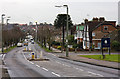
Devonshire Road from Sanders Lane
The junction in the foreground is with Ashley Walk and, on the left, Tavistock Avenue. This is the point where Sanders Lane in the past used to diverge left and cross over the railway to connect with Bittacy Hill. On the horizon, on the opposite side of the Dollis Valley, the houses of Finchley and Central House can be seen.
Image: © Martin Addison
Taken: 19 Jan 2009
0.07 miles