IMAGES TAKEN NEAR TO
Kiln Place, LONDON, NW5 4AN
Introduction
This page details the photographs taken nearby to Kiln Place, NW5 4AN by members of the Geograph project.
The Geograph project started in 2005 with the aim of publishing, organising and preserving representative images for every square kilometre of Great Britain, Ireland and the Isle of Man.

There are currently over 7.5m images from over14,400 individuals and you can help contribute to the project by visiting https://www.geograph.org.uk
Image Map
Images are licensed for reuse under creativecommons.org/licenses/by-sa/2.0
Notes
- Clicking on the map will re-center to the selected point.
- The higher the marker number, the further away the image location is from the centre of the postcode.
Image Listing (166 Images Found)
Images are licensed for reuse under creativecommons.org/licenses/by-sa/2.0
Image
Details
Distance
1
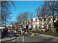
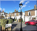
Grafton Road, Gospel Oak
At certain times of day, Grafton Road is closed to through traffic to reduce 'rat running'. The road sign in the middle of the image can change to show 'no entry'. The road has a width restriction to prevent large vehicles from using it.
Image: © Malc McDonald
Taken: 7 Mar 2015
0.04 miles


4
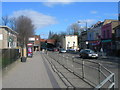
Mansfield Road, NW3 (1)
Looking towards Gospel Oak station, facing ENE. For most of the length of this road it is the boundary between NW3 and NW5 Postal Districts.
Image: © Danny P Robinson
Taken: 19 Mar 2006
0.06 miles
5
Mansfield Road, NW3 (2)
Corner of Oak Village, NW5.
Image: © Danny P Robinson
Taken: 19 Mar 2006
0.06 miles
6
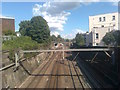
Railways near Grafton Road
As seen from Grafton Road Bridge, looking eastwards.
The lines on the left lead to Upper Holloway station (on the Gospel Oak to Barking line).
The lines on the right are part of the London Underground network (on the Northern Line) leading towards Kentish Town.
They both pass under bridges carrying the North London Line (NLL).
The white house on the right is on the very short Dale Close.
Image: © David Anstiss
Taken: 15 Aug 2017
0.06 miles
7
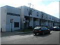
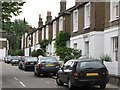
Oak Village, NW5
A few streets of attractive small Victorian houses which have managed to survive bombs and developers.
Image: © Des Blenkinsopp
Taken: 2 Feb 2016
0.07 miles

10
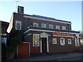
The Old Oak
The pub on the corner of Mansfield Road and Oak Village is named for the oak tree under which parishioners gathered to hear an annual gospel reading, before the area began to be developed in the mid-C19. Presumably there was an earlier pub - this one looks mid-C20.
Many old oaks were called Gospel Oaks, from the gospels that were preached from beneath their shade or shelter: a continuation of a pre-Christian practice that can be traced back to the earliest times. Gospel oaks also acted as boundary markers with clergy giving biblical readings as part of the traditional annual ceremony of the Beating of the Bounds.
Image: © Natasha Ceridwen de Chroustchoff
Taken: 14 Nov 2007
0.09 miles