IMAGES TAKEN NEAR TO
Grampian Gardens, LONDON, NW2 1JH
Introduction
This page details the photographs taken nearby to Grampian Gardens, NW2 1JH by members of the Geograph project.
The Geograph project started in 2005 with the aim of publishing, organising and preserving representative images for every square kilometre of Great Britain, Ireland and the Isle of Man.

There are currently over 7.5m images from over14,400 individuals and you can help contribute to the project by visiting https://www.geograph.org.uk
Image Map
Images are licensed for reuse under creativecommons.org/licenses/by-sa/2.0
Notes
- Clicking on the map will re-center to the selected point.
- The higher the marker number, the further away the image location is from the centre of the postcode.
Image Listing (37 Images Found)
Images are licensed for reuse under creativecommons.org/licenses/by-sa/2.0
Image
Details
Distance
1
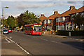
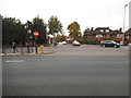
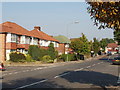
Pennine Drive
Pennine Drive, as befits its name, forms the backbone of this 1930's housing estate around which concentric side roads form an oval pattern. The side roads are all named after ranges of hills and areas adjoining the Pennines. This is the junction with Cleveland Gardens on the left and Cumbrian Gardens on the right.
First DML44087 on the 226 route catches the evening sun as it waits for a 102 going in the other direction.
Image: © Martin Addison
Taken: 10 Oct 2009
0.09 miles
2
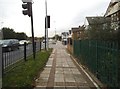
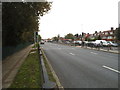
The pavement on Hendon Way, Cricklewood
Image: © David Howard
Taken: 24 Oct 2014
0.09 miles
3
Hendon Way at the junction of Pennine Drive
Image: © David Howard
Taken: 24 Oct 2014
0.09 miles
6
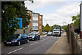
Wayside
This street connects the A41 Hendon Way with the vale and is a popular route into the back streets of Golders Green for those drivers who know the area. The skip lorry has just come off the A41 which is visible in the distance.
The road has a sign prohibiting buses and vehicles over 7.5 tonnes from travelling in the direction that this photo is looking, but similar restrictions do not seem to apply in the direction that the skip lorry is travelling. These may be in force due to the sharp turn required to join the A41 at the far end.
Image: © Martin Addison
Taken: 28 May 2010
0.13 miles
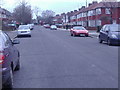
7
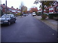
Pennine Drive, Cricklewood
This housing estate is noticeable on the map as the layout has two concentric ellipses and a central spine, which is Pennine Drive. Other streets also have hilly names - Cheviot, Cumbrian, Cotswold, Chiltern, Cleveland, Quantock and Grampian Gardens, Purbeck Drive.
Image: © David Hawgood
Taken: 15 Oct 2005
0.14 miles
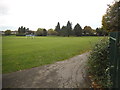
8
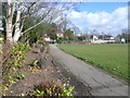
Path along the edge of Basing Hill Park
The area where Basing Hill Park is now was open fields until the 1920s, when it was developed for housing. In 1936 the ground was laid out as a park to serve the local people. Details and a little more history is given at http://www.londongardensonline.org.uk/gardens-online-record.asp?ID=BAR005
This view looks along the edge of the park towards one of the entrances - see http://www.geograph.org.uk/photo/4372125
Image: © Marathon
Taken: 4 Mar 2015
0.15 miles