IMAGES TAKEN NEAR TO
Peachman Way, Broadland Business Park, NORWICH, NR7 7SH
Introduction
This page details the photographs taken nearby to Peachman Way, Broadland Business Park, NR7 7SH by members of the Geograph project.
The Geograph project started in 2005 with the aim of publishing, organising and preserving representative images for every square kilometre of Great Britain, Ireland and the Isle of Man.

There are currently over 7.5m images from over14,400 individuals and you can help contribute to the project by visiting https://www.geograph.org.uk
Image Map
Images are licensed for reuse under creativecommons.org/licenses/by-sa/2.0
Notes
- Clicking on the map will re-center to the selected point.
- The higher the marker number, the further away the image location is from the centre of the postcode.
Image Listing (165 Images Found)
Images are licensed for reuse under creativecommons.org/licenses/by-sa/2.0
Image
Details
Distance
1

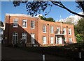
The Broadland District Council Offices
As seen from the car park.
Image: © Evelyn Simak
Taken: 14 Mar 2019
0.01 miles
2
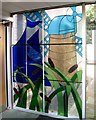
The Broadland District Council Offices - stained glass window
This window was designed and made by trainees at Broadland Council Training Services and installed in May 1991. It can be seen just before entering reception.
Image: © Evelyn Simak
Taken: 14 Mar 2019
0.01 miles
3

Elephants at Reception
Photographed by kind permission of staff at reception, at the Broadland Council Offices.
Image: © Evelyn Simak
Taken: 14 Mar 2019
0.01 miles
4
Thorpe Lodge
Thorpe Lodge dates from between 1755 and 1842, but some think that it looks earlier. When the Broadland District Council offices were built adjacent to it in 1974, there were reports of underground passages in the vicinity, which may be tunnels under the road leading to the staithe on the other side, or to chalk workings. The Grade 2 listed building is currently occupied by offices of the Broadland District Council.
Image: © Evelyn Simak
Taken: 14 Mar 2019
0.02 miles
5

The Broadland District Council Offices
As seen from across Yarmouth Road.
Image: © Evelyn Simak
Taken: 14 Mar 2019
0.02 miles
6

Broadland District Council Emergency Centre
Government emergency centres are frequently referred to as War Headquarters and were constructed specifically for government executives to retreat to in the event of a nuclear fall-out during the Cold War era. It is situated adjacent to the council offices, at the end of the council staff car park.
Image: © Evelyn Simak
Taken: 14 Mar 2019
0.02 miles
7
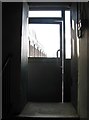
Broadland District Council Emergency Centre - entrance
View out of the entrance/exit which is protected by a heavy steel blast door. This photo also illustrates very well the thickness (3ft) of the exterior wall. (The door with the glass window is a recent addition, installed to protect the original entrance.) Part of the council offices building can be seen in the background at left. For a view of the stairwell leading down to the bunker's lower level see > https://www.geograph.org.uk/photo/6087645.
Image: © Evelyn Simak
Taken: 14 Mar 2019
0.02 miles
8

Broadland District Council Emergency Centre - the kitchen
The kitchen is still in place and the appliances are fully functional.
Image: © Evelyn Simak
Taken: 14 Mar 2019
0.02 miles
9
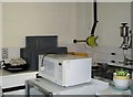
Broadland District Council Emergency Centre - the kitchen
The kitchen is still in place and the appliances are fully functional. The object on the wall in the background is a pump supplying the kitchen with filtered and purified water from one of the three water tanks > https://www.geograph.org.uk/photo/6087462 also situated in this bunker.
Image: © Evelyn Simak
Taken: 14 Mar 2019
0.02 miles
10

Broadland District Council Emergency Centre - ventilation
The external ventilation openings are protected by steel covers. For an internal view of the air pressure equalisation valves see > https://www.geograph.org.uk/photo/6087656.
Image: © Evelyn Simak
Taken: 14 Mar 2019
0.02 miles