IMAGES TAKEN NEAR TO
Ashleigh Court, CWMBRAN, NP44 6HG
Introduction
This page details the photographs taken nearby to Ashleigh Court, NP44 6HG by members of the Geograph project.
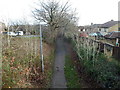
The Geograph project started in 2005 with the aim of publishing, organising and preserving representative images for every square kilometre of Great Britain, Ireland and the Isle of Man.

There are currently over 7.5m images from over14,400 individuals and you can help contribute to the project by visiting https://www.geograph.org.uk
Image Map
Images are licensed for reuse under creativecommons.org/licenses/by-sa/2.0
Notes
- Clicking on the map will re-center to the selected point.
- The higher the marker number, the further away the image location is from the centre of the postcode.
Image Listing (115 Images Found)
Images are licensed for reuse under creativecommons.org/licenses/by-sa/2.0
Image
Details
Distance
1
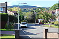
Ashleigh Court, Cwmbran
Part of housing estate west of Coed Meyric-moel LNR. Mynydd Henllys is on the skyline.
Image: © M J Roscoe
Taken: 9 Oct 2018
0.08 miles
2
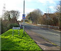
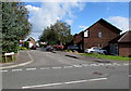
Henllys Way reaches Henllys, Cwmbran
The Cwmbran district of Henllys contains an older section named Henllys Village or
The Village, and a larger area of houses built since about 1990.
The roadside railings are along the bridge carrying Henllys Way over a brook, Nant-y-milwr.
Image: © Jaggery
Taken: 7 Jan 2012
0.09 miles
3
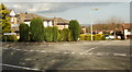
Ashleigh Court, Henllys, Cwmbran
Viewed from Henllys Way.
Image: © Jaggery
Taken: 8 Apr 2010
0.09 miles
4
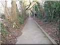
The Incline
This footpath known locally as "The Incline" follows the path of the tramway for several miles from the site of the old Henllys Colliery to the Monmouthshire and Brecon at Two Locks
Image: © gj
Taken: 26 Jan 2006
0.10 miles
5
Footpath along route of former industrial tramway, Cwmbran
The footpath descends away from an underpass beneath Henllys Way. This was originally part of the route of Incline Tramway from Henllys Colliery to the Monmouthshire & Brecon canal at Two Locks. The cars on the left are parked in a residential street named Tramway Close.
Image: © Jaggery
Taken: 7 Jan 2012
0.10 miles
6
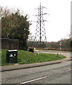
Telecoms cabinets and electricity pylon, Henllys, Cwmbran
Looking east from Henllys Village Road. The pylon is in a field behind Henllys Way.
Image: © Jaggery
Taken: 4 Apr 2020
0.10 miles
7
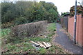
Path alongside Coed Meyrick-moel Nature Reserve, Cwmbran
Public footpath, from The Incline, between Gwent Wildlife Trust's reserve and the rear of Ashleigh Court. The reserve's woodland in the background is a remnant of ancient oak woodland. The timber in the foreground is to repair the steps down into the meadow, left.
Image: © M J Roscoe
Taken: 8 Nov 2016
0.11 miles
8
Wern Fach Court, Cwmbran
Cul-de-sac viewed across Pensarn Way. The name sign on the left is in English only.
The bilingual sign on the right shows that Wern Fach Court is Cwrt Wern Fach in Welsh.
Image: © Jaggery
Taken: 30 May 2016
0.12 miles
9
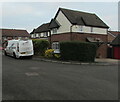
Secure Wise white van, Hendre Court, Cwmbran
In the Henllys area of Cwmbran.
Image: © Jaggery
Taken: 7 Dec 2020
0.12 miles
10
Wern Fach Court, Henllys, Cwmbran
Viewed from Pensarn Way. Wern Fach Court is a cul-de-sac built in the early 1990s.
Image: © Jaggery
Taken: 9 Oct 2016
0.12 miles