IMAGES TAKEN NEAR TO
Brynglas Road, NEWPORT, NP20 5QF
Introduction
This page details the photographs taken nearby to Brynglas Road, NP20 5QF by members of the Geograph project.
The Geograph project started in 2005 with the aim of publishing, organising and preserving representative images for every square kilometre of Great Britain, Ireland and the Isle of Man.

There are currently over 7.5m images from over14,400 individuals and you can help contribute to the project by visiting https://www.geograph.org.uk
Image Map
Images are licensed for reuse under creativecommons.org/licenses/by-sa/2.0
Notes
- Clicking on the map will re-center to the selected point.
- The higher the marker number, the further away the image location is from the centre of the postcode.
Image Listing (271 Images Found)
Images are licensed for reuse under creativecommons.org/licenses/by-sa/2.0
Image
Details
Distance
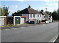
1
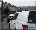
Whimsical notice on the back of a car parked alongside Brynglas Road, Newport
The yellow notice shows "IF YOU CAN READ THIS, I HAVE LOST MY CARAVAN".
Image: © Jaggery
Taken: 13 Apr 2020
0.03 miles
2
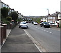
Towards a bend in Brynglas Road, Newport
On the descent towards Malpas Road.
Image: © Jaggery
Taken: 13 Apr 2020
0.04 miles
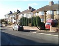
3
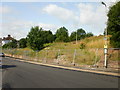
Brynglas Avenue site of demolished prefabs, Newport
Fencing segregates the area formerly containing prefabs. A prefab http://www.geograph.org.uk/photo/1981336 was a prefabricated single-storey house.
At the time of this photo (August 2009), there was no sign of redevelopment work.
Near the top of Brynglas Avenue, close to a bend to the west to join Brynglas Road.
Image: © Jaggery
Taken: 13 Aug 2009
0.04 miles
4
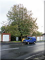
Joinery van alongside tree, Brynglas Avenue
The tree is in a gap between garages on Brynglas Avenue adjacent to the spot where the road makes a 90 degree turn. Despite the van belonging to Woodside Joinery, there was no evidence that raw materials were about to be collected.
Image: © Jaggery
Taken: 25 Oct 2009
0.04 miles
5
Isolated group of houses, Brynglas Avenue, Newport
These houses on the east side of Brynglas Avenue are separated from houses to the north by a 50-metre row of garages and from houses to the south by a 60 metre wide open space. http://www.geograph.org.uk/photo/1643009
Image: © Jaggery
Taken: 6 Oct 2010
0.04 miles
6
Newport : Brynglas Avenue houses between a bend and an empty site
These houses on the western side of Brynglas Avenue are located next to a sharp bend (just behind the camera) and a fenced-off area, http://www.geograph.org.uk/photo/1460348 roughly 180 metres by 50 metres, formerly the site of prefabs.
A prefab was a prefabricated single-storey building http://www.geograph.org.uk/photo/1981336, many of which were erected in Newport to help meet a severe housing shortage after the Second World War.
Image: © Jaggery
Taken: 25 Nov 2010
0.04 miles
7
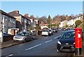
View up Brynglas Road from a postbox, Newport
Looking towards the Brynglas Avenue junction.
Image: © Jaggery
Taken: 28 Dec 2013
0.04 miles
8
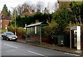
Brynglas Avenue bus shelter and BT phonebox, Newport
Located near the Brynglas Avenue junction. The stop is used by buses towards the city centre. In January 2016, this route is operated by NAT (New Adventure Travel). It was previously operated by Newport Bus.
Image: © Jaggery
Taken: 5 Jan 2016
0.04 miles
9
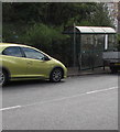
Vehicles parked in a Brynglas Road bus stop, Newport
No buses here and elsewhere in the city today, Easter Monday April 13th 2020.
Image: © Jaggery
Taken: 13 Apr 2020
0.04 miles
10
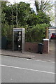
Brynglas Road Newport phonebox - but for how much longer?
In April 2020 a BT notice dated 6/11/19 in the phonebox
states "We're thinking about removing this payphone"
Image: © Jaggery
Taken: 13 Apr 2020
0.04 miles