IMAGES TAKEN NEAR TO
Eric Coates Walk, NEWPORT, NP19 9PD
Introduction
This page details the photographs taken nearby to Eric Coates Walk, NP19 9PD by members of the Geograph project.
The Geograph project started in 2005 with the aim of publishing, organising and preserving representative images for every square kilometre of Great Britain, Ireland and the Isle of Man.

There are currently over 7.5m images from over14,400 individuals and you can help contribute to the project by visiting https://www.geograph.org.uk
Image Map
Images are licensed for reuse under creativecommons.org/licenses/by-sa/2.0
Notes
- Clicking on the map will re-center to the selected point.
- The higher the marker number, the further away the image location is from the centre of the postcode.
Image Listing (71 Images Found)
Images are licensed for reuse under creativecommons.org/licenses/by-sa/2.0
Image
Details
Distance
1
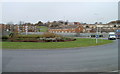
Ringland Way roundabout, Newport
Looking towards Ringland Circle and Hendre Farm Drive from the southern side of the Ringland Way roundabout.
Image: © Jaggery
Taken: 26 Nov 2010
0.01 miles
2
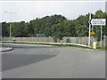
City Centre that way
Direction sign on the A48 at Hartridge Farm Road roundabout.
Image: © J Whatley
Taken: 22 Sep 2010
0.03 miles
3
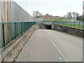
Underpass to Hartridge Farm Road, Newport
A path from Hendre Farm Drive leads to an underpass beneath Ringland Way. In the distance is Hartridge High School.
Image: © Jaggery
Taken: 26 Nov 2010
0.06 miles
4
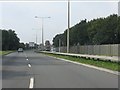
Between the roundabouts
The A48 seen from the exit of Hartridge Farm Road roundabout, with the next junction plainly in view.
Image: © J Whatley
Taken: 22 Sep 2010
0.06 miles
5
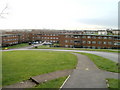
Morley Close flats, Newport
Viewed from Dunstable Road. Morley Close contains 36 flats, 12 in each of 3 buildings, built in the 1960s.
Image: © Jaggery
Taken: 26 Nov 2010
0.06 miles
6
Ringland Way approaches Hartridge roundabout, Newport
The view NE along the A48, here named Ringland Way. At the roundabout ahead, turn right for Hartridge Farm Road leading to:
Hartridge High School http://www.geograph.org.uk/photo/2176615
Ysgol Gymraeg Casnewydd http://www.geograph.org.uk/photo/2176591
RSPCA Animal Centre http://www.geograph.org.uk/photo/2176829
Road Safety Centre http://www.geograph.org.uk/photo/2176759
The wooden fence http://www.geograph.org.uk/photo/2189199 on the left is intended to shield houses from the noise of the A road.
Image: © Jaggery
Taken: 5 Dec 2010
0.06 miles
7
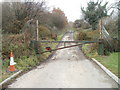
Lane blocked by metal barrier, Ringland, Newport
The lane, located between Ringland Way (A48) and Hartridge Farm Road, leads to disused sewage works.
Image: © Jaggery
Taken: 26 Nov 2010
0.06 miles
8
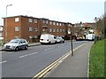
Ringland Circle flats, Newport
A building containing 12 flats, located on the west side of Ringland Circle, near the turning for Aberthaw Road. http://www.geograph.org.uk/photo/2175759
Image: © Jaggery
Taken: 26 Nov 2010
0.07 miles
9
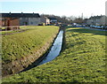
Small stream, Ringland, Newport
This small, unnamed stream drains much of Ringland. Viewed here from the corner of Aberthaw Road and Ringland Circle, looking along the east side of Sullivan Circle.
The stream empties into Liswerry Pill Reen (drainage channel), about a kilometre away.
Image: © Jaggery
Taken: 5 Dec 2010
0.07 miles
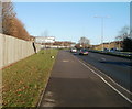
10
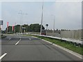
Approaching Hartridge Farm Road roundabout
Seen from Ringland Way, part of the A48 Newport southern bypass.
Image: © J Whatley
Taken: 22 Sep 2010
0.07 miles