IMAGES TAKEN NEAR TO
River Row, BLACKWOOD, NP12 0EH
Introduction
This page details the photographs taken nearby to River Row, NP12 0EH by members of the Geograph project.
The Geograph project started in 2005 with the aim of publishing, organising and preserving representative images for every square kilometre of Great Britain, Ireland and the Isle of Man.

There are currently over 7.5m images from over14,400 individuals and you can help contribute to the project by visiting https://www.geograph.org.uk
Image Map
Images are licensed for reuse under creativecommons.org/licenses/by-sa/2.0
Notes
- Clicking on the map will re-center to the selected point.
- The higher the marker number, the further away the image location is from the centre of the postcode.
Image Listing (49 Images Found)
Images are licensed for reuse under creativecommons.org/licenses/by-sa/2.0
Image
Details
Distance
1
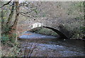
Pont Syr Dafydd, The Rock
South west side of eighteenth century stone road bridge (grade II listed) over the River Sirhowy, looking upstream. The Sirhowy Valley Walk crosses the bridge.
Image: © M J Roscoe
Taken: 21 Nov 2015
0.04 miles
2
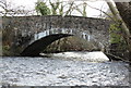
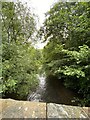
Pont Syr Dafydd, The Rock
North east side of eighteenth century stone road bridge (grade II listed) over the River Sirhowy, looking downstream. The Sirhowy Valley Walk crosses the bridge, seen in Image
Image: © M J Roscoe
Taken: 21 Nov 2015
0.04 miles
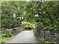
4
River Sirhowy, Oakdale
Looking upstream from road bridge carrying the Sirhowy Valley Walk.
Image: © M J Roscoe
Taken: 8 Jul 2015
0.05 miles
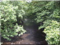
6
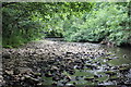
River Sirhowy below Pont Syr Dafydd
Looking upstream towards the stone arched bridge after a dry period.
Image: © M J Roscoe
Taken: 22 Jul 2016
0.05 miles
7
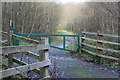
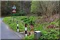
Footpath, bottom of Rhiw Syr Dafydd Hill, The Rock
Path near River Sirhowy. Pedestrian access is to the left of the gate.
Image: © M J Roscoe
Taken: 21 Nov 2015
0.06 miles
8
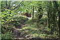
Woodland footpath down to The Rhiw
The house sign on the wall on the other side of the road says, '3 Rhiw Cottages'. The path veers to its right and continues uphill from the camera to become path Image The wood is part of the Penmaen Woodlands SINC.
Image: © M J Roscoe
Taken: 25 Apr 2020
0.06 miles
9
Stream, Rhiw Syr Dafydd Hill, Rock
An unnamed tributary of the River Sirhowy; the discoloration of the stream bed is presumably caused by leachate from the disused colliery waste tip on the hillside. The stream disappears under the road and then flows south west before entering the river.
Image: © M J Roscoe
Taken: 6 May 2016
0.08 miles
10
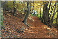
Woodland path up to Oakdale
Path leads up the hillside from a minor road, The Rhiw, to the former B4251. The wood is part of the Penmaen Woodlands Site of Importance for Nature Conservation.
Image: © M J Roscoe
Taken: 1 Nov 2015
0.08 miles