IMAGES TAKEN NEAR TO
Gwendoline Road, NEWPORT, NP11 6DD
Introduction
This page details the photographs taken nearby to Gwendoline Road, NP11 6DD by members of the Geograph project.
The Geograph project started in 2005 with the aim of publishing, organising and preserving representative images for every square kilometre of Great Britain, Ireland and the Isle of Man.

There are currently over 7.5m images from over14,400 individuals and you can help contribute to the project by visiting https://www.geograph.org.uk
Image Map
Images are licensed for reuse under creativecommons.org/licenses/by-sa/2.0
Notes
- Clicking on the map will re-center to the selected point.
- The higher the marker number, the further away the image location is from the centre of the postcode.
Image Listing (254 Images Found)
Images are licensed for reuse under creativecommons.org/licenses/by-sa/2.0
Image
Details
Distance
1
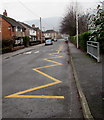
Zigzag markings on Gwendoline Road, Risca
The yellow markings define the Keep Clear Zone (no parking or stopping) outside Risca Primary School.
Image: © Jaggery
Taken: 20 Dec 2016
0.00 miles
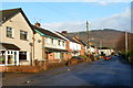
2
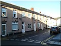
Wesley Place, Risca
Houses on the west side of the street, viewed from the corner of Tredegar Terrace.
Image: © Jaggery
Taken: 30 Nov 2011
0.03 miles
3
Risca Primary School
The school is located on a site bordered by Graig View, Danygraig Road and Gwendoline Road. This view was taken along Graig View on November 30th 2011, when the school was closed because of a nationwide strike by public sector workers.
Image: © Jaggery
Taken: 30 Nov 2011
0.03 miles
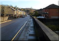
4
Gwendoline Road, Risca
Looking south from the Danygraig Road end. The houses are all on the west side of the road. The east side is the perimeter of Risca Primary School. http://www.geograph.org.uk/photo/2715165
Image: © Jaggery
Taken: 30 Nov 2011
0.03 miles
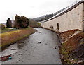
5
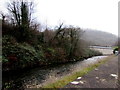
Ebbw River, Risca
Viewed from near the entrance http://www.geograph.org.uk/photo/5232578 to Stores Field rugby ground looking along the Ebbw towards the A467. The Ebbw (Afon Ebwy in Welsh) is a major tributary of the River Usk.
Image: © Jaggery
Taken: 20 Dec 2016
0.04 miles
6
Gwendoline Road, Risca
Looking north along Gwendoline Road from the edge of a rugby club's car park on the east bank of the River Ebbw.
Image: © Jaggery
Taken: 30 Nov 2011
0.04 miles
7
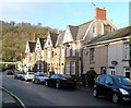
Danygraig Road houses, Risca
Houses on the north side of the road, near the Graig View junction.
Image: © Jaggery
Taken: 30 Nov 2011
0.04 miles
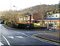
8
Risca : Looking east along Danygraig Road from the river bridge
Viewed along the bridge over the River Ebbw looking in the direction of Tredegar Street.
Image: © Jaggery
Taken: 30 Nov 2011
0.04 miles
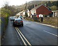
9

Gwendoline Road speed bump, Risca
The speed bump is in a 20mph maximum speed zone past Risca Primary School.
Image: © Jaggery
Taken: 20 Dec 2016
0.04 miles
10
River Ebbw downstream from Danygraig Road bridge, Risca
Viewed from the river bridge seen here. http://www.geograph.org.uk/photo/3408902
The structure carrying the A467 is on the right.
Image: © Jaggery
Taken: 11 Apr 2013
0.05 miles