IMAGES TAKEN NEAR TO
Upper Viaduct Terrace, NEWPORT, NP11 3PH
Introduction
This page details the photographs taken nearby to Upper Viaduct Terrace, NP11 3PH by members of the Geograph project.
The Geograph project started in 2005 with the aim of publishing, organising and preserving representative images for every square kilometre of Great Britain, Ireland and the Isle of Man.

There are currently over 7.5m images from over14,400 individuals and you can help contribute to the project by visiting https://www.geograph.org.uk
Image Map
Images are licensed for reuse under creativecommons.org/licenses/by-sa/2.0
Notes
- Clicking on the map will re-center to the selected point.
- The higher the marker number, the further away the image location is from the centre of the postcode.
Image Listing (139 Images Found)
Images are licensed for reuse under creativecommons.org/licenses/by-sa/2.0
Image
Details
Distance
1
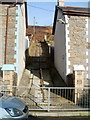
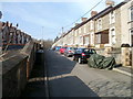
Path up to hillside from Upper Viaduct Terrace, Crumlin
The path is between numbers 13 and 14 Upper Viaduct Terrace.
Image: © Jaggery
Taken: 17 Feb 2011
0.03 miles
2
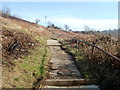
Hillside path above Upper Viaduct Terrace, Crumlin
The path is reached via this route http://www.geograph.org.uk/photo/2752159 from Upper Viaduct Terrace.
Image: © Jaggery
Taken: 17 Feb 2011
0.03 miles
3
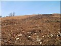
Brown winter upland landscape between Crumlin and Sofrydd
There is very little green in this mid-February 2011 view from a hillside path http://www.geograph.org.uk/photo/2752168 above Upper Viaduct Terrace, Crumlin, looking up the hill towards Sofrydd.
Image: © Jaggery
Taken: 17 Feb 2011
0.04 miles
5
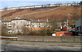
A distant view of Lewis Street, Sofrydd
The line of houses on the top of the hill are part of Lewis Street, Sofrydd, about 250 metres from the viewpoint, across the A467 in Crumlin.
Image: © Jaggery
Taken: 17 Feb 2011
0.06 miles
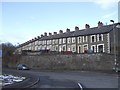
6
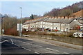
Lower Viaduct Terrace, Crumlin
Viewed across the A467.
Image: © Jaggery
Taken: 17 Feb 2011
0.07 miles
7
Crumlin : Lower Viaduct Terrace viewed from Crumlin Road
Crumlin Road was formerly a through route to the B4471 between Sofrydd and Llanhilleth. After subsidence, part of the road ahead was permanently closed in 2006. http://www.geograph.org.uk/photo/2635541 Walkers can used a footpath through the affected area.
Image: © Jaggery
Taken: 17 Feb 2011
0.07 miles
8
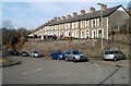
Lower and Upper Viaduct Terrace, Crumlin
On the left are the backs of houses in Lower Viaduct Terrace.
On the right are the fronts of houses in Upper Viaduct Terrace.
Image: © Jaggery
Taken: 17 Feb 2011
0.07 miles
9
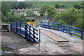
Temporary bridge at Navigation Colliery, Crumlin
Bridge over River Ebbw culvert in the grounds of the former colliery as part of preparations for widening the railway bridge Image downstream (to the right). Behind is the concrete retaining wall for the A467.
Image: © M J Roscoe
Taken: 16 Aug 2020
0.07 miles
10
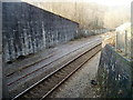
Partly buried disused railway track, Crumlin
Viewed from Crumlin Road adjacent to the A467 road bridge. The track on the right is used by Ebbw Valley line trains travelling in both directions. There are points and double tracks at most of the stations to allow trains to pass each other. A token system ensures that two trains can never occupy one
section of single track. The next station ahead is Llanhilleth.
The disused track on the left has almost disappeared under ballast.
Image: © Jaggery
Taken: 17 Feb 2011
0.08 miles