IMAGES TAKEN NEAR TO
Swaledale Close, NOTTINGHAM, NG8 5FW
Introduction
This page details the photographs taken nearby to Swaledale Close, NG8 5FW by members of the Geograph project.
The Geograph project started in 2005 with the aim of publishing, organising and preserving representative images for every square kilometre of Great Britain, Ireland and the Isle of Man.

There are currently over 7.5m images from over14,400 individuals and you can help contribute to the project by visiting https://www.geograph.org.uk
Image Map
Images are licensed for reuse under creativecommons.org/licenses/by-sa/2.0
Notes
- Clicking on the map will re-center to the selected point.
- The higher the marker number, the further away the image location is from the centre of the postcode.
Image Listing (29 Images Found)
Images are licensed for reuse under creativecommons.org/licenses/by-sa/2.0
Image
Details
Distance
1
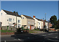
Nuthall Road: Newcastle Terrace
These cottages date from the sinking of Thomas North's Newcastle Colliery (on land owned by The Duke of Newcastle) in 1853. The colliery, which was directly ahead, behind the terrace, closed in 1928, but a landsale wharf, where coal brought by rail from Cinderhill Colliery was supplied to coal merchants, survived until c. 1966 (it is still shown on 1967 OS maps). The houses of Staindale Drive and Wensleydale Close are built on the site of the wharf and associated railway sidings.
For more about the Babbington Colliery Railway, see Image], Image], Image], Image] and others linked from them.
Image: © John Sutton
Taken: 13 Sep 2011
0.07 miles
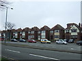
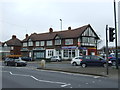
3
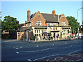
Newcastle Arms
The name is derived from the Duke of Newcastle who owned most of the coal concessions in the area. The pub is a typical 1930s roadhouse, designed to serve the council estate behind it. Note the fine ceramic frontage complete with coloured coat of arms. This pub has not suffered from unnecessary renaming!
Image: © Alan Murray-Rust
Taken: 4 Jun 2008
0.11 miles
4
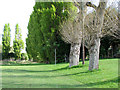
Melbourne Park: where there was once a busy railway
The almost imperceptible embankment to the right of the pollarded poplars in the foreground marks the shunting neck of the National Coal Board railway line which connected Babbington (Cinderhill) Colliery with the extensive fan of sidings at the Nuthall Road landsale wharf, which lay behind the green poplars, where the Staindale Drive housing development now stands. This railway had originally been built by Thomas North, the colliery owner, to connect Babbington to the Nottingham Canal, due south at Wollaton Road, and later the Midland Railway line from Radford to Trowell at Babbington Sidings, near where Western Boulevard Bridge now stands. The line south of Melbourne Park had been long abandoned (since the building of Western Boulevard in the 1930s) by the time I sat on the swings just out of picture to the left and watched a little green locomotive named Peter shunting NCB East Midlands Division No 6 Area wagons, which were black with white lettering and bright yellow corner ironwork. The line of the railway can still be made out near where it crosses Melbourne Road a little way north of here - see Image
Image: © John Sutton
Taken: 11 May 2010
0.11 miles
5
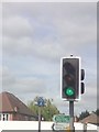
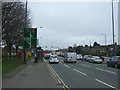
UK Green Traffic Light Signal
UK Green Traffic Light Signal at the Crossroads junction on the Nuthall Road, joining the Western Boulevard, Bypass at Nottingham Nottinghamshire.
Image: © gary
Taken: 15 Jun 2015
0.12 miles
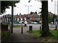
7
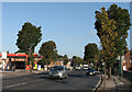
Nuthall Road
Before nine on a bright September morning the majority of traffic is coming in to the city. Newcastle Colliery (1853-1928) and later Newcastle Landsale Wharf stood to the left, taking their name (as did the nearby pub) from the landowner, The Duke of Newcastle. This area was developed in the 1930s, at the same time as Western Boulevard.
Image: © John Sutton
Taken: 13 Sep 2011
0.13 miles
8
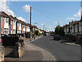
Newlyn Drive
This road of detached houses is very typical of the western suburbs developed in the 1930s. I must have walked or cycled along here many times in the 1950s (when most of the window and door woodwork was green-and-cream, or grained), on my way to play at Melbourne Park, which is behind the houses on the left.
Image: © John Sutton
Taken: 11 May 2010
0.13 miles
9
Sign of the times
On the quiet and chilly morning of the royal wedding bank holiday a sandwich-board man looks less than thrilled to be advertising pizzas on the corner of Western Boulevard and Nuthall Road.
Image: © John Sutton
Taken: 29 Apr 2011
0.13 miles
10
Western Boulevard (A6514)
Nottingham Ring Road - looking south west.
Image: © JThomas
Taken: 27 Mar 2017
0.13 miles