IMAGES TAKEN NEAR TO
Kingsford Avenue, NOTTINGHAM, NG7 5QR
Introduction
This page details the photographs taken nearby to Kingsford Avenue, NG7 5QR by members of the Geograph project.
The Geograph project started in 2005 with the aim of publishing, organising and preserving representative images for every square kilometre of Great Britain, Ireland and the Isle of Man.

There are currently over 7.5m images from over14,400 individuals and you can help contribute to the project by visiting https://www.geograph.org.uk
Image Map
Images are licensed for reuse under creativecommons.org/licenses/by-sa/2.0
Notes
- Clicking on the map will re-center to the selected point.
- The higher the marker number, the further away the image location is from the centre of the postcode.
Image Listing (243 Images Found)
Images are licensed for reuse under creativecommons.org/licenses/by-sa/2.0
Image
Details
Distance
2
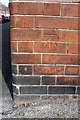
Benchmark on #75 Grimston Road
Ordnance Survey cut mark benchmark described on the Bench Mark Database at http://www.bench-marks.org.uk/bm47871
Image: © Roger Templeman
Taken: 31 Mar 2013
0.04 miles
3
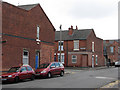
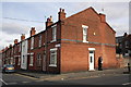
Churchfield Lane: former corner shops
The new brickwork shows that the houses on the corners of Wordsworth Road were once shops. Fifty years on, it seems remarkable how many sweet and paper shops once served the children of Bobbers Mill and Radford. This was once on the western edge of Victorian and Edwardian Nottingham. The streets to the west of Churchfield Lane (to the right and behind the camera), extending as far as the River Leen, date from the late 1930s.
Image: © John Sutton
Taken: 12 Jul 2011
0.04 miles
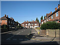
4
Junction of Grimston Road and Churchfield Lane
There is an OS benchmark Image on the corner of the near house
Image: © Roger Templeman
Taken: 31 Mar 2013
0.04 miles
5
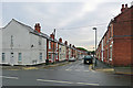
Down Churchfield Lane
To the right are houses at what was the edge of the built-up city until the inter-war years, to the left ones built in the late 1930s. The Art Deco curves of the former Capitol Cinema, now a gospel church, show at the bottom of the hill. The rest of the day was bright, but although early-morning mist had cleared, before nine o'clock the sun had yet to burn through low cloud.
Image: © John Sutton
Taken: 20 Apr 2015
0.05 miles
6
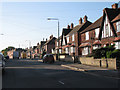
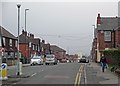
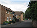
Along Grimston Road
Looking towards Radford Boulevard and Alfreton Road from Churchfield Lane on a grey September morning. Until the late 1930s this was the edge of Nottingham in these parts. Behind the camera are houses built just before the War as the city began the huge westward expansion which continued in the fifties and sixties. The white house on the left used to be a corner sweet shop.
Image: © John Sutton
Taken: 12 Sep 2018
0.05 miles
7
Churchfield Lane
The former Capitol Cinema, now a gospel church, is on the corner of Churchfield Lane and Newquay Avenue.
Image: © John Sutton
Taken: 24 Sep 2009
0.05 miles
8
The newer part of Woodstock Avenue
Woodstock Avenue and the other roads west of Churchfield Lane were developed in the 1930s. This part, next to the River Leen, was once the site of a woodyard (whose other entrance was on Lynmouth Crescent, beyond the red car and trees at the far end) and lorry park. It was good to reminisce about these things with a friendly passer-by.
Image: © John Sutton
Taken: 12 Jul 2011
0.05 miles
9
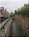
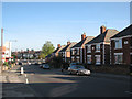
Churchfield Lane: up the entry
The passage leading to the back yards of houses on Wordsworth Road. The yards of the houses on Glentworth Road (on the right) are further up the hill and supported by a substantial Bulwell stone retaining wall. It was a wet and drab early-summer morning in Radford, but the day cleared up later.
Image: © John Sutton
Taken: 2 Jun 2015
0.05 miles