IMAGES TAKEN NEAR TO
Lacewood Close, NOTTINGHAM, NG6 8ZL
Introduction
This page details the photographs taken nearby to Lacewood Close, NG6 8ZL by members of the Geograph project.
The Geograph project started in 2005 with the aim of publishing, organising and preserving representative images for every square kilometre of Great Britain, Ireland and the Isle of Man.

There are currently over 7.5m images from over14,400 individuals and you can help contribute to the project by visiting https://www.geograph.org.uk
Image Map
Images are licensed for reuse under creativecommons.org/licenses/by-sa/2.0
Notes
- Clicking on the map will re-center to the selected point.
- The higher the marker number, the further away the image location is from the centre of the postcode.
Image Listing (50 Images Found)
Images are licensed for reuse under creativecommons.org/licenses/by-sa/2.0
Image
Details
Distance
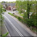
1
Nottingham - NG6 (Bestwood)
A stretch of Moor Road (B683) just before it is becomes Bestwood Road (a.k.a. the B683) taken from halfway up a set of steps. The steps take a pavement-level footpath up an embankment to join a nature trail that follows the route of a former railway line.
Image: © David Hallam-Jones
Taken: 16 May 2012
0.07 miles
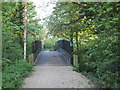
2
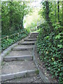
Nottingham - NG6 (Bestwood)
This set of steps connects the pavement alongside Moor Lane (B683) with a public footpath that follows a former railway line. At the top of these steps a wide metal footbridge has been installed to allow walkers and cyclists to cross the (B683) at embankment-top level and thereby to join the Robin Hood Trail hereabouts, should they so wish to.
Image: © David Hallam-Jones
Taken: 16 May 2012
0.08 miles
3
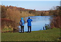
Nottingham, NG6 - Bestwood
One of the "Mill Lakes" in Mill Lakes Country Park from one of the footpaths that encircle it. The water in River Leen that replenishes the lake is seen continuing its journey - at the feet of the birdwatching couple - towards the Moor Bridge tram stop vicinity. This country park is situated between the Nottingham-Mansfield railway line (The Robin Hood Line) on one side and the B683 road on the other, at the point where these two converge to form the apex of an thin inverted triangle at the boundaries of the Ashfield District Council and Nottingham Borough Council administrative areas.
Image: © David Hallam-Jones
Taken: 17 Nov 2012
0.08 miles
4
Dismantled Great Northern Railway crosses Moor Road, Bestwood
"This was the Great Northern Railway from Leen Valley Junction northwards. It was one of three railways in the Leen Valley - Midland the first, GNR the second and Great Central the last. The GNR line lost its passenger service as early as 1931 (apart from seaside specials from Sutton in Ashfield), but carried coal until 1968. If you have a look at some of the other pictures for this square, you'll see the former passenger station as it once was and now is, as well as one-time railway cottages and where the (wooden) platforms once were."
Description from Geographer John Sutton (Nottinghamian and railway and cricket bore)
Image: © Chris Morgan
Taken: 10 Mar 2014
0.09 miles
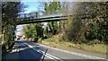
5
Nottingham - NG6 (Bestwood)
This metal bridge carries a nature trail footpath over Moor Lane (B683). The path runs on top of an embankment along a former railway line that probably used to carry coal away from some of the local pits. This is the view looking in the Bestwood Road direction.
Image: © David Hallam-Jones
Taken: 16 May 2012
0.09 miles
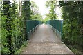
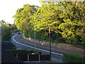
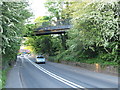
7
Bridge over Moor Road
Carrying NCN route 6 and the Robin Hood Way. In the past this would have been a railway bridge
Image: © David Lally
Taken: 27 Apr 2017
0.09 miles
8
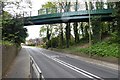
Nottingham - NG6 (Bestwood)
Looking back in the Bestwood Village direction at a stretch of Moor Road (B683) to where a relatively recently installed footbridge carries a nature trail - following a former railway track - across and above the B683.
Image: © David Hallam-Jones
Taken: 16 May 2012
0.10 miles
9
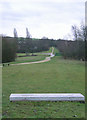
Bestwood Country Park- Mill Lakes area
This is the alignment of the former Great Northern Railway Leen Valley branch. As well as being part of the Robin Hood Way at this point, it is also part of the Sustrans cycle network. The concrete slab in the foreground is a seat, and is inscribed "One million years of pressure", presumably with reference to the formation of the coal seams.
This view is in the opposite direction to Image
Image: © Alan Murray-Rust
Taken: 13 Jan 2008
0.11 miles