IMAGES TAKEN NEAR TO
Hillview Avenue, NOTTINGHAM, NG3 5GA
Introduction
This page details the photographs taken nearby to Hillview Avenue, NG3 5GA by members of the Geograph project.
The Geograph project started in 2005 with the aim of publishing, organising and preserving representative images for every square kilometre of Great Britain, Ireland and the Isle of Man.

There are currently over 7.5m images from over14,400 individuals and you can help contribute to the project by visiting https://www.geograph.org.uk
Image Map
Images are licensed for reuse under creativecommons.org/licenses/by-sa/2.0
Notes
- Clicking on the map will re-center to the selected point.
- The higher the marker number, the further away the image location is from the centre of the postcode.
Image Listing (66 Images Found)
Images are licensed for reuse under creativecommons.org/licenses/by-sa/2.0
Image
Details
Distance
1
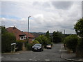
Hill View Avenue, Mapperley
Seen from Private Road, the reason for its name is fairly obvious. The land also slopes away quite steeply behind the houses on the right.
Image: © Richard Vince
Taken: 14 Jul 2012
0.02 miles
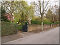
2
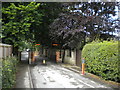
Barrier on Private Road, Mapperley Park
This barrier prevents Private Road from being used by through traffic between Mansfield Road (out of sight in the distance) and Woodborough Road (some way behind the photographer). The rising bollard type device can be retracted by residents using some sort of electronic device.
Image: © Richard Vince
Taken: 14 Jul 2012
0.06 miles
3
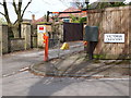
Nottingham - NG5/NG3 boundary
A view of the traffic control barrier situated at the halfway point on Private Road (sic), adjacent to Victoria Crescent. This picture was taken from the Mansfield Road end of this semi-private road. (No. 32, Victoria Crescent, a stone’s throw away from this barrier is where D.H. Lawrence lodged between 1906-08 whilst he was a trainee-teacher student at University College, Nottingham.) This electronic barrier was installed circa 1997 to replace a wooden gate that, whilst effective in deterring unauthorised traffic, became a nuisance for local residents using their cars. A certain Samuel Cartledge owned the Mapperley Place Estate that surrounds what is now called Private Road, up to and including Mapperley Mount at the top end of this hilly road. He also owned a nearby brickyard and its associated cottages. According to the Poll Book of 1832 nine voters lived alongside this private road and three others lived in the "Plains" or the Brickyard Cottages. The Mapperley cricket field was previously just off Private Road too.
Image: © David Hallam-Jones
Taken: 22 Apr 2012
0.06 miles
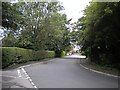
4
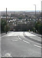
Mapperley Rise
Or more appropriately 'descent' in this direction. One of the many steep roads in the north east sector of Nottingham resulting from the heavily incised valleys in the local mudstones. It links Mapperley (on top) with Sherwood below.
Image: © Alan Murray-Rust
Taken: 8 Mar 2009
0.06 miles
5
Nottingham - NG5
This could be considered either the end or the beginning of the semi-circular shaped road known as Victoria Crescent. This start or end point is adjacent to the electronic traffic-control barrier positioned at the mid-point along Private Road. Seen here is No.32 where D.H.Lawrence lodged between 1906-08 whilst he was a trainee-teacher student at University College (later Nottingham University). Pedestrians descending the hilly roads from “Mapperley Top” down to the suburb of Sherwood often stop to enjoy the impressive views from this particular point. On a clear day it is said to be possible to ‘see’ Crich in Derbyshire (20 or so miles away). As a result many of Lawrence’s admirers have suggested that his inspiration for the phrase in one of his books “where Nottingham’s hills roll down to Derbyshire's plains” may have resulted from those occasions when he would have gazed out towards Derbyshire from the bay window that can be seen under the eaves of this house to the right of the tree trunk.
Image: © David Hallam-Jones
Taken: 22 Apr 2012
0.06 miles
6
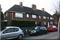
Nos. 34 to 28 (evens) Morley Avenue
Ordnance Survey documents indicate that a benchmark was levelled at 116.778m above Newlyn Datum in 1962 on the side of the left hand house at its front corner
Image: © Luke Shaw
Taken: 1 Feb 2020
0.07 miles
7
Gordon Rise, Mapperley
Seen from Private Road (which actually continues as the turning to the left in the foreground), Gordon Rise appears unpopulated. However, it is surrounding by housing, albeit at a different level from the road at this point.
Image: © Richard Vince
Taken: 14 Jul 2012
0.07 miles
8
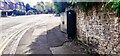
Mapperley Rise (opposite #70) at Cresta Gardens junction
There is an Ordnance Survey benchmark Image on the wall behind the green cabinet
Image: © Roger Templeman
Taken: 8 May 2022
0.07 miles
9
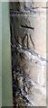
Benchmark behind cabinet on SW side of Mapperley Rise
Ordnance Survey cut mark benchmark levelled at 92.345m above Newlyn Datum verified 1962
Image: © Roger Templeman
Taken: 8 May 2022
0.08 miles
10
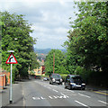
Mapperley Rise
Looking down this steep road which links Sherwood and Mapperley Top. The east of the city is hilly and there is a long view across Sherwood and Basford to the hills beyond Strelley which separate Nottingham from the Erewash Valley.
Image: © John Sutton
Taken: 17 Jun 2014
0.08 miles