IMAGES TAKEN NEAR TO
Bentinck Court, NOTTINGHAM, NG2 4PE
Introduction
This page details the photographs taken nearby to Bentinck Court, NG2 4PE by members of the Geograph project.
The Geograph project started in 2005 with the aim of publishing, organising and preserving representative images for every square kilometre of Great Britain, Ireland and the Isle of Man.

There are currently over 7.5m images from over14,400 individuals and you can help contribute to the project by visiting https://www.geograph.org.uk
Image Map
Images are licensed for reuse under creativecommons.org/licenses/by-sa/2.0
Notes
- Clicking on the map will re-center to the selected point.
- The higher the marker number, the further away the image location is from the centre of the postcode.
Image Listing (341 Images Found)
Images are licensed for reuse under creativecommons.org/licenses/by-sa/2.0
Image
Details
Distance
1
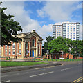
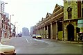
Sneinton Road: contrasts
On the left is the former Albion Congregational Church (1856). Further away are the high-rise Bentinck Court flats, built by Nottingham City Council.
Image: © John Sutton
Taken: 3 Jun 2017
0.01 miles
2
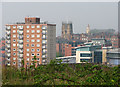
Sneinton view - 2
The view - foreshortened by a zoom lens - from Windmill Lane, outside The Queen Adelaide public house. On the horizon to the right of the tower block are the tower of St Mary's Church, the spire of the former High Pavement Unitarian Chapel (now a bar) and, in the distance, Nottingham Castle.
Image: © John Sutton
Taken: 15 Apr 2011
0.02 miles
3
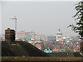
Sneinton view - 1
A foreshortened zoom view from Windmill Lane, over the rooftops of Walker Street, towards the Council House and the unpleasant high-rise blocks of Maid Marian Way.
Image: © John Sutton
Taken: 15 Apr 2011
0.03 miles
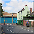
6
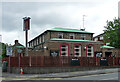
Painting the bus depot doors
A view along Eyre Street towards the Manvers Street side of Parliament Street Bus Depot. The King William IV is on the corner of Manvers Street.
Image: © John Sutton
Taken: 13 Apr 2016
0.04 miles
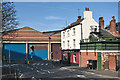
7
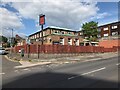
Sneinton: changes in Eyre Street
Since I took Image] in April 2016 The King William IV public house has closed and changed colour.
Image: © John Sutton
Taken: 3 Jun 2017
0.04 miles
8
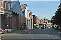
Manvers Street
Looking towards Sneinton Market from a pedestrian refuge at the corner of Pennyfoot Street. The Nottingham City Transport bus depot is on the left and in the distance the Park View Court tenement shows above the market avenues.
Image: © John Sutton
Taken: 16 Aug 2016
0.04 miles
9
Nottingham in the 1980s - Bus Garage on Manvers Street
This was a surprisingly similar scene in 2020.
Image: © Nigel Thompson
Taken: 2 Feb 1982
0.04 miles
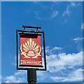
10
The Wheatsheaf, Sneinton Road, Nottingham
Estate pub built in 1964 by C. Howitt & Partners.
Image: © Stephen Richards
Taken: 19 Jun 2015
0.04 miles